Pages

Wednesday, November 2, 2016

MCH History Blog On the Road: The Chambers House

Recently I was talking to my late-elementary school aged daughter about researching and writing. I told her that it's not unusual for you to have one idea about where you think an investigation will go before you start, and then have it end up going in a different direction once you start uncovering the actual facts. That is just what happened when I decided to look into the history of the Chambers House, located in Brandywine Hundred near Bellefonte, at the corner of Lore Avenue and Brandywine Boulevard. It's a beautiful Queen Anne style home on a corner lot, stylistically different from the comfortable early-century homes around it, yet somehow fitting in to the neighborhood.

I had known of the house before, but only that it was named for a former, high-level DuPont employee who had owned it for several decades. A few weeks ago I came across the name of the person who was credited for building the home in about 1894, so I was naturally curious as to who this person was who built such a stately home for the area. I had only her name to go on at first, but I ultimately did trace the ownership of the property from the early 1800's through the mid 1900's. I can honestly say that every step of the way had a "So that's who that was" moment, but in the end I can't quite answer the fundamental question at hand here -- Who built the Chambers House, and when?

Thursday, September 22, 2016

Lamborn, Guest, and the Bunco Steerers

The location of Chandler Lamborn's farm
In the last post we saw two articles telling tales of attempted swindling aimed at MCH resident David E. Eastburn. These occurred in July and November of 1888, with the earlier article referencing another successful ploy targeting a different MCH farmer. Since the bunco steerers (gosh I love that term) failed with Eastburn, it was unclear as to what exactly their plan was. But now, thanks to the research ability of Donna Peters (contributor of the first articles), we not only have a detailed account of the heretofore briefly mentioned incident, we have another story that appears to involve the same con artists. And although the new incident didn't take place in Mill Creek Hundred, it does end up having connections both to Mill Creek Hundred and (sort of) myself.

We'll get to the new story in a moment, but first let's catch up and find out exactly what happened to Chandler Lamborn. All we knew from the Eastburn article was that three days after failing with him, the swindlers succeeded in taking $500 from Lamborn. They left the area soon thereafter. The article below gives a detailed account of just what went down that day. It appeared the same day as the Eastburn article, July 14,1888, but in a different paper, the Wilmington Every Evening. It was all a complex scheme to get the 71 year old Lamborn to gather a substantial amount of money together so that they could steal it, literally, right out of his hands.

Wednesday, September 21, 2016

The Attempted Scamming of David Eastburn

David E. Eastburn
It's an unfortunate fact of life that as adults in the world today, we're (hopefully) all very aware of the existence of con artists. Nowadays they can approach you in many ways, whether it's via phone calls (usually during dinner), emails from important-sounding foreigners, or their frightening-sounding presidential campaign commercials. In the 19th Century, however, they mostly had to do it the hard way -- in person. I'm sure there were things like fraudulent newspaper ads then, too, but in 1888 if someone wanted to separate you from your money or possessions, they usually had to do it face to face.

One consequence of this is that the con artists and criminals of the time had to pick their prospective targets more carefully. Unlike today's scammers who can blast out to thousands or millions their claims of fast riches, unlikely enhancements, or impractical walls, the cons of yesteryear had to spend time on their marks. Therefore, they'd want to find someone worth targeting. And in 1888, apparently someone (or someones) thought that Mill Creek Hundred's David Eastburn was a worthwhile target. Two separate newspaper articles from that year (graciously supplied by Donna Peters) detail shady interactions with him.

Friday, August 26, 2016

The 4th Delaware, Company E Reunion

Cpt. David E. Buckingham
Without question, the defining event for the United States in the 19th Century (if not ever) was the Civil War. For the soldiers involved, as well as their families, it was the most exciting and terrifying period of their lives. I'm sure anyone around now who has endured more recent military service can attest to this. One of the big differences, though, between the Civil War and more recent conflicts is the scale. About 10% of the population served in the war and about 2% died. This would be equivalent to over 32 million people in the service and almost 6.5 million dead today. The only thing that remotely compares was World War II, where the service percentage was comparable but the death toll was much lower.

War is, as I've heard, hell, but even through the carnage that was the Civil War the soldiers found at least one positive experience to take away from it -- camaraderie. These predominantly rural men, many of whom who lived on isolated farms, suddenly found themselves surrounded 24/7 by their fellow soldiers. They did everything together, relying on each other for companionship and, often, their very survival. When they eventually returned home to their farms, many had no one to talk to about their experiences and missed the brotherhood in which they had been immersed in the army. It's no wonder that in the decades following the war many attempts were made to rebuild the kind of camaraderie the men had felt in the service.

Tuesday, August 16, 2016

The Charles S. Philips Photographic Collection

Greenbank Mill and the Philips House
There are many resources available to historical researchers in their attempts to reconstruct and make sense of the past. Public documents like censuses, birth, death, and marriage certificates, and government reports can give you an idea of what was going on where. Personal documents like letters and diaries can give insights into the why's of past lives. But for my money (such as it is) there's nothing quite like old photographs. Somehow, actually looking at an image (no matter how blurry) of a person or a place can make them seem real in a way that words on paper never can.

From what I've seen, at least, most of the historic photographs we have from the late 19th/early 20th Century era tend to come to us from professional photographers. Some are portraits taken in a formal studio, while many others were likely taken "in the field" by itinerant photographers. These were men (mostly) who traveled around with their camera and equipment and took pictures of those in rural areas who didn't have easy access to a studio in the nearest city. Some of these same itinerants took many of the photos for the postcards of the day, too.

All that being said, once in a while we're lucky enough to have some photos from a different kind of source -- an amateur photographer. Cameras were certainly not as common then as they are now, but they were not impossible to get or use, either. (In my own family, I have a great-great grandfather who had a camera in that era, and took some really cool shots. One was a triple exposure with three of him sitting around a table playing cards.) However, the process of taking and developing photographs at that time was still fairly involved. The people who did it really liked photography, and were probably very methodical people. They took pictures of things that interested them. We're fortunate enough that one such person like this hailed from Mill Creek Hundred, and came back to the area to take some wonderful photographs. Many of these photographs will be on public display later this month (August 2016).

Wednesday, August 10, 2016

St. Barnabas' Episcopal Church

St. Barnabas' Church, pre-1911
As with many rural areas in the 18th and 19th Centuries, some of the main pillars and binding points of the community in Mill Creek Hundred were its houses of worship. Early arrivers like the Quakers, Presbyterians, and Episcopalians set up their churches and meeting houses as soon as there were enough members to fill them. Many of these were firmly in place by the mid-1700's. Later groups like the Methodists and Catholics were not far behind. Initially in MCH, with the slight exception of Stanton (Cuckoldstown), there were no real towns or villages to speak of. Congregations usually built their churches wherever someone would sell or donate land.

By the later 19th Century, though, a few small areas did manage to grow to at least village status. One of these locales was the mill town of Marshallton. The iron works there had been running and growing since the early 1800's, and the village with it. Additionally, just a short walk away sat the little factory village of Kiamensi. All the workers living there (or at least, most of them) attended one church or another each Sunday. The Presbyterians would walk up Duncan Road to Red Clay Creek Church, which wasn't too far away. The Methodists went to Stanton originally, until they built their own church in 1886.

The Episcopalians of Marshallton and Kiamensi had even further to go. They were forced to walk to either Old St. James Church on the other side of Stanton, or to the other St. James Church in Newport. By the late 1880's, Marshallton and Kiamensi residents began to take matters into their own hands. [I should note at this point that much of the following information comes from the wonderful history posted on the church's website, written by Judy Reinicker and others.] What would eventually become St. Barnabas Episcopal Church began as a church school sometime prior to 1890, working as an extension of St. James Church in Newport. There was no church building yet, and members simply met in each others houses.

Tuesday, July 19, 2016

A Few More Added Odds and Ends

The Dennison House
This is not so much a coherent post (if you'll give me the benefit of the doubt that most of them are) as it is a showcase for a few unrelated items that I've recently added to older posts. None of them quite justify their own separate posts, but all of them are interesting enough to be saved from falling through the cracks. So far only one item has even been mentioned in a comment, while another has been posted over on the blog's Facebook page. Let's start with that one, because it's the coolest photograph of the group.

The picture, seen to the right, is of the Samuel Dennison House on Limestone Road. It comes to us courtesy of Jim Derickson, whose father Jim, Sr. was the last owner of the Derickson Farm along McKennans Church Road. Jim's mother was the former Mildred Dennison, daughter of Frank and Mary Dennison. She grew up in the home that now houses office space for the Summit Retirement Community. Mildred's brothers, Frank, Jr. and Howard, were the last of the Dennisons to work the farm. I don't know the exact date of the photo, but my guess is that it could be from the late 1800's. The aerial photo below is much later, having been taken in the 1950's. It shows the Dennison Farm, sitting on both sides of Limestone Road running up to the north.

Monday, July 11, 2016

The Lost (?) Pilling Houses of Kiamensi

Was this one of the Pilling Houses?
This was just going to be a reply to a new comment in an old post, but the more I thought about it the more I realized that it needs more. This is mostly questions without answers at this point, but there's enough new information that there's a hope that it might lead to more someday. The comment in question came from Dave C. and was posted on a story I wrote about Powell Ford. Dave shared with us an interesting newspaper article he found, which originally appeared in the September 2, 1910 edition of the Wilmington Every Evening. I'll repost the article in its entirety in a moment, but first a refresher on the people involved.

Englishman Thomas Pilling (1836-1905) was, along with his brother John, one of the founders of the Kiamensi Woolen Company in 1864. The Kiamensi Woolen Mill sat on the northwest corner of Kiamensi Road and Red Clay Creek, just south of Marshallton. The company eventually owned more or less all the land between the B&O (now CSX) tracks and Kiamensi Road, from Stanton Road to just east of the creek. They also owned a good amount of land south of Kiamensi Road, too. Just how much, we'll get to shortly.

Friday, July 1, 2016

The Zachariah Derickson House -- The Derickson Farm Through the 19th Century and Beyond

The Derickson House in the 1950's
In the last post, we took a look at the early history of the land surrounding the Zachariah Derickson House, and the families who owned it. We saw that the land goes back to a 17th Century land grant called Wedgebury, which ended up in the Robinson family. The land around Milltown was subsequently broken up, then, after some intermediate transactions, Samuel Montgomery purchased about 200 acres in 1766. The heirs of his son William ultimately sold what was remaining to their sister Martha and her husband, Zachariah Derickson.

Derickson was originally from Christiana Hundred, hailing from the area we now know as Prices Corner. Before leaving, Zachariah even sold a two acre lot to David Price, the man whose name is still evident today in such places as shopping center signs and bowling alley names. The evidence seems to indicate that Zachariah and Martha moved to the house on McKennans Church Road in 1842. Even today, 174 years after Zachariah's purchase and 250 years after their ancestor Samuel Montgomery first bought the land, the Derickson family still owns a small part of that original tract. In between, though, it's passed through numerous generations of Dericksons.

Friday, June 24, 2016

The Zachariah Derickson House -- The Early History of the Land and Family

The Zachariah Derickson House
One of the challenges in researching the historic properties in Mill Creek Hundred is that many of them have long-ago passed out of the hands of the families who built and originally lived in them. This means that the people who would be most invested in a site's history, and the ones who would presumably have the most information about it, are out of the equation. In a few lucky cases, however, -- like the Cox-Mitchell House, the Ward-Dudkowitz House, and Woodside Creamery (the Mitchell Farm) -- the property (or a nearby one) is owned by a member of the family who long occupied it. Fortunately this is the case with an old home that, while not exactly hidden, is probably unknown to most who drive by it -- the Zachariah Derickson House.

Located on the west side (left if you're going uphill) of McKennans Church Road between Milltown Road and Delcastle Golf Course, this Derickson house has been keeping watch down the hill for about two centuries now. And while the first decades of its existence still contain a few questions, most of the history of this house is well-documented. Aiding in this documentation is the fact that someone with the Derickson name has been living in or near it since at least 1842. If you jump to Zachariah's wife's family, the current Dericksons can trace their presence on the same land back to 1766.

Thursday, June 16, 2016

The Roseville Covered Bridge

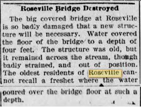
We'll take a quick detour now between the last post and next post (both regarding the Milltown area) to introduce a site that I'm pretty sure I was unaware of before this week -- the Roseville Covered Bridge. I've written several times in the past about the Roseville area, which is located along Kirkwood Highway just west of Possum Park Road. The posts have mostly focused on the mill seat located there or the neighboring farm (I hate to keep teasing upcoming posts, but one soon will again mention a planned later iteration of the Roseville Mill). I was aware that there was a bridge there, crossing White Clay Creek, but I didn't know it was a covered bridge.

This shouldn't have been too surprising, really. All the surrounding crossings (Paper Mill, Red Mill, and Harmony) had, at one time, covered bridges. There's no real reason why Roseville shouldn't have also. The reason why I had never heard of it before can be explained by the August 19, 1901 newspaper mention of the bridge seen above (courtesy, as usual in these cases, of Donna Peters). And although, to paraphrase a contemporary author, reports of its death were greatly exaggerated, the Roseville Covered Bridge did not last quite as long as did some of the others spanning the borders of Mill Creek Hundred.

Friday, June 10, 2016

Filling in the Gaps at the Robinson-Harlan-Chandler Mill

It all started with Wedgebury
As I've said a few times lately, one of the things I'd like to do with the new resources available to me is to go back and fill in the holes in the histories of certain sites. As it turns out, I've been able to do a decent job of just that with one of the very first sites I covered here on the blog. I actually started out piecing together the history of a neighboring site (which will be the topic of an upcoming post), but since the two were originally part of the same tract it became very easy for me to jump tracks.

The site in question here is the Harlan-Chandler Mill Complex, located on the southwest corner of Limestone Road and Milltown Road. The original post dealt mostly with the 19th Century history of the site, covering the ownerships of the Harlan brothers and the Chandler family. Only brief mention was made of its earlier history, noting that it was originally the Robinson Mill and at some point Caleb Harlan took over. (Most of the recent attention has been on the burnt and being-rebuilt Chandler House, which is about a century newer than the time-frame we'll look at now.)

Friday, May 27, 2016

The Benefits of Primary Sources

Polly Drummond's 1838 purchase of her tavern property
As I mentioned recently both here and on the Facebook page, I've had access the past few weeks to a great many new (to me) primary sources. So far, the most helpful of these have been the Delaware land records and will/probate records. Like everything in life, there are pros and cons to this new world open to me. On the up side, I can mine data and facts from the original sources with out relying on things like Scharf and Runk, which, while well-intentioned, are riddle with errors. On the down side, it provides even more of a chance for me to get distracted and taken off course.

Some of the distraction part is sort of baked into the cake -- deeds can be thought of as individual links in a longer chain. Each one gives you not only information about the next one (this one's buyer is the next one's seller) but, as I've found, very often loads of information about the previous ones. In order to prove that the seller (or, grantor. buyer is the grantee) has legal claim to the land in question, the deed often gives background information on the property. Usually it's along the lines of "being the same tract or parcel granted by so and so by indenture dated such and such a date." Once in a while the chain of ownership is complicated enough that it may go back several steps or include other information. Needless to say, this can be enormously helpful.

Friday, May 13, 2016

Montgomery Follow-Up with New Resources

First Page of Moses Montgomery's 1848 will
I want to start by saying that this is not a paid endorsement, I'm just passing along information to those who might be interested. A few months ago I was tipped off (thanks, Walt) to the fact that Ancestry.com now includes a whole slew of Delaware land records, as well as will and probate information. Even though it's not cheap (at least to someone like me), my wife and I decided to treat ourselves to a subscription to see if it would be of use (she's doing a lot of genealogical research right now). I'm still figuring out exactly how to use it, but I've already come up with some information that I never would have had before, considering that I really don't have the time to schlep down to Dover to look for this stuff in person.

The land records are not complete, and I'm still learning to decode one and two hundred year old legalese, but a few new things have come to light already. I actually started out looking up something else, which happened to be connected to another branch of the Montgomery family. Somehow, I quickly ended up back on the same Montgomery land I just left. One of the more interesting things I've found is the Last Will and Testament of Moses Montgomery, first written in 1848 (and amended a few years later).

Friday, April 29, 2016

The Montgomery Family Cemetery

The Montgomery Family Cemetery
Whenever you're doing genealogical or historical research, one of the best sources of information has to be cemetery records. Whether you're looking for a birth date, death date, denominational affiliation, or just the correct spelling of a name (at least at the time), there's no better way to get the information than literally written in stone. I use this all the time (with the help of sites like Find-A-Grave) in my Mill Creek Hundred research.  The churchyards at Red Clay Creek Presbyterian, White Clay Creek Presbyterian, Ebeneezer Methodist, St. James Episcopal, the three Friends Meeting Houses (Hockessin, Mill Creek, and Stanton), and others have loads of great information on the past residents of MCH.

The problem, though, is that not everyone can be found at these official, church cemeteries. While most people chose to be interred in hallowed ground, some chose to remain closer to their beloved homes. Especially earlier in the history of the area, some families created and used private family cemeteries on a portion of their property. I don't think anyone knows how many of these family cemeteries there were, and I don't think we will.

Wednesday, April 27, 2016

In Memory -- Gertrude Mitchell Bell and Anna Mae Hedrick

I don’t usually do obituaries here, but there are two recent notable passings that I thought I should mention. Both were wonderful people, had been mentioned in posts in the past, and had long-time links to the area. In fact, between the two of them they had over 200 years’ worth of connections to Mill Creek Hundred.

Our first loss occurred back in February, when Gertrude Mitchell Bell passed away at the age of 103. She was the daughter of John C. Mitchell and the granddaughter of John Mitchell. It was John Mitchell who, in 1868, purchased the Cox-Mitchell House (aka Ocasson) on Old Wilmington Road east of Hockessin. Trudy grew up in Hockessin, long before it was the Hockessin we know today. When I had the pleasure of meeting her a few years ago (I think she was “only” 99 at the time), I swear she remembered more about the Hockessin of the 20’s and 30’s than I remember of last year. She was a sweet, kind woman, a trait passed down to the rest of her family. And speaking of which, I can report that the now 290 year old house will remain with the family. They have a great deal of love and respect for the home, which bodes well for the future of the house I call The Birthplace of Hockessin.

The second notable passing, occurring earlier this week, was Anna Mae Hedrick of Marshallton. Ann had just turned 100 in January, and with the exception of the last few years in a nursing home had lived her entire life in her beloved Marshallton. She grew up, fell in love, and raised her family all there in the village which she saw greatly change over the course of her life. As she tells it, Marshallton was “out in the country” when she was young. I first met Anna Mae through the Friends of Brandywine Springs, where she was the last remaining member of the group who had actually attended the amusement park. She enjoyed showing off the scar on her arm that she got from the slide in the funhouse. She was also a longtime member of the Mill Creek Fire Company, even driving the truck during World War II.


Both of these women had a special connection to their particular corners of MCH, and their presence will be sorely missed. My condolences go out to each of their families, but both can take comfort in knowing the effects that each of the special women had on countless others during their enviably long lives.

Friday, April 22, 2016

Abel Jeanes Wants a Road

Whenever I'm researching history (or even just watching a show or reading about it for fun), one of the truisms I try to keep in mind is the reality and humanity of the people who populated that past. They weren't just one-dimensional characters, they were real people, the same kind of people we have now. There were good people and bad people, generous people and greedy people, quiet people and outspoken people. And just like today, everything that they did they did for a reason. Sometimes those reasons were kind and magnanimous, sometimes they were petty and self-serving.

All this came to mind recently when I was looking back over an old newspaper article forwarded to me a while ago by Donna Peters. It originally appeared in the March 1, 1825 edition of the Wilmington paper the American Watchman, and was really more of a letter to the editor than an article. The piece, written by "A Citizen of White Clay Creek Hundred", dealt with the county's Levy Court's reconsideration and approval of an earlier denied request for a road located in western Mill Creek/northwestern White Clay Creek Hundred. The writer seems less than thrilled with the idea of the county footing the bill for the road in question.

Under normal circumstances, the Levy Court's consideration of whether or not to fund a public road would not be all that exciting or noteworthy -- it was one of its regular functions. However, in this case the story is more pertinent to us due to the identity of the petitioner for the road -- Abel Jeanes. As we've seen in several previous posts, Jeanes, co-founder with brother-in-law Joseph Eastburn of the Eastburn-Jeanes Lime Kilns, was quite a forceful personality. He was undoubtedly a good businessman, but he didn't seem to be all that concerned with being a well-liked businessman.

Friday, March 25, 2016

A Boat in a Race

In this post we'll be examining the photograph seen here, which comes to us from the collection owned by the Boulden family. When I first saw this picture, I thought, "OK, nice, it's three people standing in a rowboat." My biggest reaction was to think how brave they were to be standing on a rickety little boat in such nice clothes. However, the more I looked at it, the more it caught my interest.

I decided that I needed to figure out where the picture was taken, if I could. As it turns out, I'm sure that I do know where they are, and you'd never know it today. I can't say the location makes this photograph unique, but I'd be willing to wager that there aren't too many others like it.

Tuesday, March 22, 2016

The Mount Pleasant Inn

Possibly the semi-original Mount Pleasant Inn, maybe
A few months ago I wrote a post about the Montgomery family, and in it promised some additional posts to come regarding them. Well, here's the first one. Towards the end of that original post there was mention made of a tavern situated on the western portion of the southeastern part of the original Montgomery tract. Operating under at least three different names and numerous owners and innkeepers, a tavern was in existence here for more than a century. From the 1770's until the 1880's, the establishment last known as the Mount Pleasant Inn housed, fed, and entertained weary travelers along what is now known as Old Wilmington Road.

As I had noted in the Montgomery post, although the inn was well-known to historians not much in-depth research had ever been done on it (to my knowledge), especially relating to its early history. I am now very happy to say that that is no longer the case. The subject of the Mount Pleasant Inn caught the attention of Walt Chiquoine, and he ran with it in a fantastic way. In fact, I'm going to do something that a writer normally wouldn't do, and tell you not to even bother reading the rest of this post. Instead, go directly here and download Walt's detailed account of the history of this MCH establishment. It's informative, well-written, and meticulously researched. Absolutely well worth your time.

But, for those who can't or choose not to check out Walt's article, I'll give you my own slightly abridged version of the story, which is honestly based mostly on Walt's work. If you'll recall from the original post, John Montgomery arrived in Mill Creek Hundred about 1730 with his three sons -- Alexander, Thomas, and Robert. He purchased a large tract of land surrounding the intersection of Brackenville and Old Wilmington Roads. The southwest portion of the tract first passed from John to son Alexander, then upon Alexander's death in 1746 it went to his son John. It was this John Montgomery who may have operated the first tavern on the site.

Wednesday, March 9, 2016

Impressions of the Current State of the Springer-Little Farm

Remains of the south and west barn walls 
Finally, not long ago, I was able to get over to the site of the Springer-Little Farm highlighted in the recent post. Along with good friend of the blog Walt Chiquoine, I went to take a look to see what is still there, and to see how it has changed since the 1998 excavations undertaken by DeDOT. It was only right to do this, since it was the presence of these ruins and being told about them that started all this in the first place.

The short version of the story is that yes, there are still structural remains there. Although it appears that the DelDOT team rightly back-filled much of what they had excavated, there are still three separate sites readily visible. I know what two of them are and I think I know the third. From what I can understand of the 1998 report, though, there are two main ruin locations that have disappeared. What makes being sure so difficult is that starting a few years ago, DelDOT began redacting the online versions of their archaeology reports, removing many of the maps and diagrams originally included. Specifically here, the online version (which can be found here) is missing the maps showing the locations of the ruins relative to each other and to the road. However, with a careful reading and a better understanding of the site having been there, I think I know what's what.

Wednesday, February 24, 2016

The Springer-Little Farm

Site of the Springer-Little (then, Ward) Farm, 1868
Since I write this blog for fun, and on my own time, I try to keep it as low-pressure for myself as I can. One way I enjoy doing that is to keep it very free-flowing, as far as topics are concerned. Once in a while I have to look hard to find something to write about, but more often than not the next subject will either pop up somehow, be suggested by a reader, or come directly from the last investigation. In this case it's actually both of the last two.

In the follow-up post about the Trinder and Higgins Farms there was mention made about the family of William Little, and the fact that they resided on a farm on the southwest corner of Upper Pike Creek Road and Old Coach Road. In comments and emails several people noted that there were some stone ruins still present at the site, just off of the road. The old maps clearly show the Little Farm, but provide not much more information. (I was going to say "little more information"...this is going to be a tough one to write.) Luckily, back in the 1990's DelDOT was widening the roads in the area and commissioned an archaeological report of the sites near the intersection. Much of the information here comes from that report, which can be found here (and another one here).

Thursday, January 28, 2016

More Information about the Trinder and Higgins Farms

The area in 1868
I knew this was going to get a bit rambling to just shove into the middle of the original post, so here’s some additional information regarding and related to the Trinder property. The original post will also be edited to reflect the most current information, although it won't have as much detail as we'll get into here. All of this came from the single piece of information supplied by Donna P. in the comments section on the first post. She told us that she had found the will of Joseph Trinder from 1892, and record of the sale of the property by his executors in 1896. So for one thing, that gives us a closer range for his death.

Donna tells that the Trinder farm was sold to Alpheus Pennock. Alpheus (1849-1929) was the son of Lewis Pennock (1804-1879), who resided just south of the area focused upon here. You can see his name shown on the 1868 map segment above. After Lewis’ death in 1879, the home farm went to Alpheus. The house, which stood until the 1960’s, was located about where the grassy area is behind the Meadowood II Shopping Center and in front of Forest Oak Elementary School. It appears the house was torn down just before the school was built. Alpheus’ brother Pusey was the early 20th Century owner of the Harlan-Chandler Mill property in Milltown.

Friday, January 22, 2016

The Trinder and Higgins Farms

Recently a question was posed by a commenter on another post, asking about a couple of properties in the area around St. Marks High School, in southern central Mill Creek Hundred. Unfortunately the original houses are gone from both of these sites, but both have found new life. I was unable to find too much information about one of the locations, but I do have some stuff to share about one of the long-time owners of the second.

The first property in question was located on the north side of Pike Creek Road, about halfway between Upper Pike Creek Road to the west and All Saints Cemetery (and the entrance to St. Marks) to the east. It appears that the house was located on the west side of what's now Calan Drive, in the new development of Milltown Village. The barn is (or was, I've not been over there lately) across the street on the other side.

At this point I've been able to find precious little about this property, save the identity of its owner for the second half of the 19th Century. All of the maps from 1849 to 1893 show the owner as Joseph Trinder, an English immigrant born about 1815. His wife, Jane, two years older than he, was also born in England. This makes me think they probably met and were married there, then emigrated in the later 1830s. A Joseph Trinder is listed in the 1840 Census in Birmingham Township, Chester County (just above Painter's Crossing), so they may have lived there before moving to MCH.