If you appreciate the work done on this blog, please consider making a small donation. Thank you!

If you appreciate the work done on this blog, please consider making a small donation. Thank you!

Friday, February 23, 2018

Armstrong Family Homestead Tracts at Mt. Cuba -- Part III

The South Armstrong property on Barley Mill Road
Here is the the final of Don Prather's three fantastic posts about the Armstrongs of the Mt. Cuba area. It's amazing that it all began with one old photograph and some old-fashioned curiosity. The first two posts (here and here) introduced us to the family and the properties, and attempted to prove the location of the photo. This post looks more closely at the south property and shows some other pictures of the house...or are they? You decide. Finally, we'll get an insight into what the home meant to the surrounding community. I can't thank Don enough for all his work on this. Great job!!

Researched and Written by Donald Prather --

More About the South Property
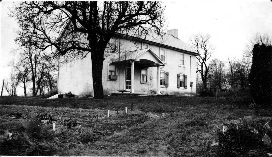
As stated in the previous post, when the south property was purchase in 1817, a stone house already existed on the property. Additional photographs acquired during our research, courtesy of Steve Armstrong, helps us understand the evolution of the house. I’m unsure whether the changes in the home represent additions to the original house or show a more extensive tear-down and rebuild. As the images below show, these changes were significant and altered the style of the home greatly but the footprint of the house doesn’t appear to have been altered significantly even as the style is updated. So, it’s possible that all of these pictures are of the same structure, but also possible that they are not. Regardless of the number of structures built, I’m certain that the properties pictured are the same because of the terrain, fence-lines, and relation of the house to the large barn and other surrounding buildings.

The earliest known image of the house can be seen in the image below. It shows a basic two-story farmhouse sitting in a fenced yard between two or three other buildings. The small building standing directly between the house and the camera appears to be a small blacksmith building or workshop with a tall chimney that appears to have been extended upwards at some point in time. It’s not hard to imagine a spark from the earlier, lower chimney causing a fire from a wandering spark or hearing the occupant of the bedroom inside that open window just a few feet from the chimney complaining about the constant smoke, heat, and the occasional hot spark. The house itself appears to be of stone construction, perhaps stuccoed-stone, but the image is not clear enough to be sure. When this first photograph was taken, the house had a simple gabled roof and at opposite ends roof are paired chimneys, penetrating the roof near the ridge with one chimney on the front pitch and the other chimney on the rear pitch.

Tuesday, February 20, 2018

Armstrong Family Homestead Tracts at Mt. Cuba -- Part II

The two Armstrong properties along Barley Mill Road
Here is the second of Donald Prather's three posts about the Armstrongs in the Mt. Cuba area and the quest to find the location of his Great-Grandmother Madolene's old photograph. In the first post, we were introduced to the photo and to the family. In this post, we'll look more deeply at the pair of Armstrong properties along Barley Mill Road, and begin trying to match the old photograph to a specific location. Thanks again to Don for his work on the project. Enjoy!

Researched and Written by Donald Prather --

The South Property, Original of the Two Tracts
As mentioned in the last post, the south property of 98 acres was originally purchased in 1817 by Archibald Armstrong. Archibald was a son of John Armstrong and a grandson of Archibald, both of whom arrived in the U.S. from Northern Ireland in the 1740’s (see notes 3 and 4). When purchased by the Armstrongs, the property contained a newer (2-3 year old) stone house and a barn, built by previous owners John and Esther Nicholson.

This south tract of land remained in the Armstrong family for 110 years and passed through four generations of the family:
  • Archibald Armstrong (original purchaser in 1817.. but likely never lived in the house)
  • Sold to his son John Armstrong Sr. (spouse Jane Delaplaine) in 1821
  • Willed to his son John Armstrong Jr (spouse Hanna K Woodward) in 1869
  • Transferred to his living children with son Joseph W. Armstrong (spouse Mary R. Guest) appointed trustee in 1913.
Joseph and his living siblings acquired the property in 1910 under the stipulation that all of his siblings (John Jr’s living children) were allowed use of the property, if desired, and had combined control over, and responsibility for, the operation, ownership, and costs of the property. Joseph was also required, as a part of the transfer, to acquire a bank loan in order to pay off the responsibilities of his father’s estate.

Thursday, February 15, 2018

Armstrong Family Homestead Tracts at Mt. Cuba -- Part I

Armstrong properties of the 18th & 19th Centuries
I want to introduce here the first of several guest posts researched and written by Donald Prather, a descendant of several MCH families (because, of course, no one comes from just one). As you'll see, this sojourn into a prominent MCH family and their holdings all started with a simple photograph found in a grandparent's attic, and the even simpler question, "Where the heck is this?" Great thanks to Don for all his hard work, and I hope you enjoy this as much as I did.

Researched and Written by Donald Prather --

Introduction
In his posts on the Mill Creek Hundred (New Castle County, Delaware) History Blog, Scott Palmer provides excellent insight into an area of northern New Castle County which came to be dominated by two groups of Armstrong family members from the late 18th century up through the early 20th century. The proliferation of properties owned by Armstrong families just north of Price’s Corner, along both Centre Road and Centerville Road, started with Robert Armstrong [(b) 1743 (d) 1821] and his purchase of the Hedgeland property, acquired some time prior to 1782. Opposite Hedgeland just across Centre Road, William Armstrong purchased and farmed a property known as Woodside, a property occupied today by the Ferris School. Just south of Woodside, across Faulkland Road, the Woodland and Brookland farms were owned and worked by generations of Armstrong families for over two centuries. And just to the northwest of these properties, down Faulkland Road and north on Centerville Road, was John Paulsen Armstrong’s Oakland farm.

Another early concentration of Armstrong family members in northern Delaware was located along today’s Barley Mill Road just south of Ashland in the immediate vicinity of the Mt. Cuba Center. This particular concentration of Armstrongs began in 1817 with a purchase of a 98 acre tract of land by Archibald Armstrong [(b) 1759 (d) 1826]. A later purchase of an adjoining property by Archibald’s son John more than doubled the size of the Armstrong presence in the area in 1842. The two adjoining properties that made up the “old homestead” consisted of 200 acres of some of the most scenic and bucolic piedmont in all of Delaware. At its peak, the combined properties contained at least three houses (one of which still exists today), barns, carriage houses, spring houses, and all the buildings necessary to maintain two working farms.

An Unidentified Photograph
This research effort started with a single unidentified photograph and the simple goal of attaching a location and a timeframe to it. Going in, I had no intention of researching or documenting this area. At the time, in fact, I didn’t even know the properties existed. But like many explorations of local history, the journey took me to new places, introduced me to new people, and taught me things about subjects I never intended to learn about. I never knew that a “looking glass” was mirror, or that a pump existed in the mid-1800’s that could deliver water hundreds of feet uphill without electricity or (nearly zero) manual effort [see note 1]!

Wednesday, February 7, 2018

The Ferguson-Worth Farm on Newport Gap Pike

Area of the Ferguson-Worth Farm, 1881
I've probably said this before (no, even I don't listen to everything I say -- please don't tell my kids), but one of the things I've come to really enjoy about writing this blog is when someone contacts me out of the blue with a simple-sounding question that turns into an in-depth, fascinating investigation. It usual starts with something like, "Do you know anything about such and such an area?" I say, "No, not particularly, but I can look into it." Then I do look into it, and I end up finding a lot more than I thought I would. And if I'm really lucky, I end up finding a few interesting stories along the way which, because it's Mill Creek Hundred, tie into other things I've researched. This has happened to me several times in the past few weeks alone, and I'd like to take the opportunity to tell you now about one of them.

This one started with an email from Beth Golden, who in the 1960's lived in the then fairly new neighborhood of Winterbury, situated on the east side of Newport Gap Pike, between Hercules Road and Loveville Road. Beth told me that she remembered an old, run-down stone barn standing in or near the development at that time. She wondered if I knew anything about the property or any of the families that had owned it. I didn't. My starting point, however, as with many of these investigations, was the old maps. The four 19th Century maps (1849, 1868, 1881, 1893) were evenly split between two names associated with the property. One led me back. The other led me forward.

Tuesday, December 26, 2017

Richard H. Williams -- Mill Creek Hundred's First Mail Carrier

(Wilmington) Morning News, September 3, 1898
I won't lie to you and say that this has been a burning question I've spent years trying to answer, but the subject of mail delivery has popped into my head now and again. As most of you probably know, rural mail delivery was next to non-existent in the early days, when you had to go to the nearest town or city (of which there were none in MCH) to send or receive mail. A bit later, as populations increased and travel became slightly easier, a few non-urban post offices began to spring up. In our area, Stanton's post office opened in 1825 and the one in Loveville along the Lancaster Turnpike opened in about 1831.

Through the remainder of the 19th Century, post offices spread to the furthest reaches of our hundred. With the introduction of the railroads, post offices began to be placed at or near stations, to aid in the ease of transport by rail. However, even up to almost the dawn of the 20th Century, if you lived in MCH and want to send or receive mail, you either had to go to the nearest post office to do so or pay for delivery by a private carrier. However, by the late 1880's many people began advocating for the implementation of a Rural Free Delivery (RFD) system to be run by the US Post Office. Although there was some opposition to it at first, the idea was ultimately adopted. And lest you think that the idea of those in power pushing for things that would benefit them personally is a new thing (it's not, although the concept may be reaching new heights these days), the Postmaster General who fought the hardest for RFD was John Wanamaker. The guy who just so happened to own a store that offered mail order items.

Nevertheless RFD finally made its way to Delaware in late 1898. And thanks to a fascinating article I recently stumbled across, I can finally answer the age-old question (just go with me on it, ok?) -- Who was Mill Creek Hundred's first mailman? The answer, it turns out, is Richard H. Williams of Marshallton. And also thanks to the same article, we know exactly when he started and even what route he took. To flesh out the story some more, I did a little digging into Mr. Williams and found that he was a pretty interesting and active man.

Friday, November 17, 2017

The Strange and Tragic Tale of Samuel Allcorn

Yeah, it's that weird
Much of the digital ink of this blog is given over to specific historical sites, whether they be houses, schools, churches, mills or other types of buildings. Often, in connection with these structures, we may look at the families associated with them. If a specific person is the subject, he or she is usually an "important" person like a politician or a doctor or a major business owner. This story, however, is about none of those things. It's about a man who should have been a pretty average late-nineteenth century resident of Mill Creek Hundred. So average, in fact, that prior to seeing the first article about him, I didn't even know who he was. I'd mentioned his father once in an old post, but until recently I knew nothing about the strange and sad tale of Samuel Allcorn.

I guess the fact that Samuel Allcorn lived an unusual life should come as no surprise if one first looks at the life of his father, George P. Allcorn. George was born in Cecil County, Maryland in November 1799, but later moved to the Milltown area. He lived there and worked as a shoemaker for the rest of his long and very productive life. In 1823, the 23 year old Allcorn married 18 or 19 year old Elizabeth Montgomery (no, not the TV witch). Elizabeth was the daughter of William Montgomery, whose house still stands on the west side of Old Limestone Road. They then got to work. Over the next 25 years or so, the couple would have ten children, the last (or next to last) being Samuel, born in 1847.

Friday, November 10, 2017

The Razing of the Jacob Derickson House

I have here a wonderfully quick follow-up to the Dericksons of Kiamensi post. In that post I came to the conclusion that the house owned by the Highway Department and shown in a 1941 photograph must have been the original Derickson house in this area. I also guessed by looking at it that it may very well have dated all the way back to Jacob Derickson in the 1820's. Finally, I estimated that the house had been torn down by the state in the early 1960's. Turns out I was right on almost every point.

Hours after I posted the story, newspaper-story-finder-extraordinaire Donna Peters sent me this article, taken from the March 15, 1958 edition of the Wilmington Morning News. It details the Highway Department's destruction of the building to allow for expansion of their Kiamensi Yard. The article confirms that this was, in fact, the Derickson's house. The writer claims that it had been standing for 150 years. If literally true, then it would predate Jacob Derickson's purchase of the property. My guess, however, is that "150 years" was an off-the-cuff estimate. If it were Jacob's, it would certainly be more than 100 years old by then, closer to 130. That's close enough for me. Below is the rest of the article, which also mentions the "old Pilling mansion", which is the Mansion House we know. It sits on the south side of Kiamensi Road, just east of Powell Ford Park. You can click on the article to see a larger version.


Monday, November 6, 2017

The Dericksons of Kiamensi

The Jacob Derickson House
Since I write this blog for fun and on my own time, I have great flexibility in choosing topics to research. Basically, I just write about whatever interests me at that given moment. Sometimes ideas come from me just poking around. The most satisfying situation, though, is when a seemingly simple question ends up taking me in directions I didn't expect and to answers I didn't know I'd be looking for. It's even better when, as in this case, the question comes from someone asking about their own ancestors.

The original query was simply from a woman looking for more information about her great-great grandfather Cornelius Derickson, and his son-in-law, her great grandfather Morris Highfield. I'd come across the Highfield family before but not, to my knowledge, Morris. I've definitely written about the Dericksons, but I was pretty sure Cornelius was not a part of their line. Certainly related, but I didn't know how. I did know, however, that on the old maps there was a C. Derickson whom I had neatly danced around in previous investigations into the Marshallton and Kiamensi area. It turns out that it was time to get to know the Dericksons of Kiamensi.