If you appreciate the work done on this blog, please consider making a small donation. Thank you!

If you appreciate the work done on this blog, please consider making a small donation. Thank you!

Tuesday, November 15, 2022

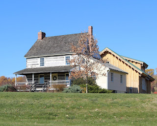
The Buckingham-Pierson House

The Buckingham-Pierson House today
When a house stays around for long enough, it usually will pass through a number of different owners. Normally it ends up being a combination of passing to various generations of the same family and being sold off to different families. One house in Hockessin, however, had the good fortune to remain in one family for over 260 years, although it took me a little while to realize that. The beginnings of the house and farm reach back to the earliest days of European habitation in the area, and its present and future look strong and secure.

The home in question is the Buckingham-Pierson House (or Thomas Pierson House), located on the north side of Southwood Road, about mid way between Valley Road and Limestone Road. The half stone and half frame house sits up on a rise, today overlooking modern housing developments. Once, it overlooked a 100 acre farm and even passing trains. Now a part of modern, beautiful Hockessin, the origins of the farm date back to the Penn family, when the community surrounding the Hockessin Valley was in its infancy.

In 1701, William Penn had a 30,000 acre tract (called the Manor of Stenning) surveyed by Henry Hollingsworth, lying mostly in Chester County but extending down into Mill Creek Hundred (the tract, not Hollingsworth). That same year Penn granted the western 14,500 acres to his son William, Jr. and the eastern 15,500 acres to his daughter Letitia. Letitia Penn married William Aubrey, and in the ensuing years they sold off portions of their holding. More importantly for our purposes, in 1725 they sold a 100 acre lot to a man named William Buckingham. Direct descendants of Buckingham's would retain ownership of the property until half way through the George H.W. Bush administration.

Wednesday, October 26, 2022

Guest Post -- The Strouds of Stanton, Delaware

I am always thrilled and proud to host Guest Posts here (if anyone wants to write something, let me know!), and this one is no exception. This particular installment focuses on the Stroud Family, several members of which had impacts on our region, most notably in the Stanton area. Our guest author, Charles Stroud Gawthrop, is a direct descendant of one of these Strouds who resided near Stanton, and whose home will be the focus of an upcoming post of its own. This well-researched account will help your understanding of the family and should help to put these Stroud Family members into better context for us. It's a great example of what amazing things can be accomplished even by someone who is admittedly new to historical/genealogical research. Many thanks to Charles for researching, writing, and sharing his work with us here! Enjoy! --- Scott


Headstone of Samuel Stroud, Jr.,
direct ancestor of the author

My name is Charles Stroud Gawthrop. A few years ago I was reading the The Mill Creek Hundred History Blog and there was a posting about the Stanton Hotel which mentioned James Stroud. Then there was the posting about the Stanton Mills mentioning Joshua Stroud - hmmm! So I started to do a little digging to see if I was related. I’m new to this genealogy thing. Prior to 2021, I had heard of Ancestry.com, but that was about it - so there was a lot to learn. Little did I know how addictive it is (and sadly how expensive Ancestry is). 

Yes, I am related to Samuel Stroud (brother of James and Joshua). Time went by and pieces of the puzzle were falling together, to a point that I realized I have some information to share.

One of the the things that impresses me about Scott Palmer, the webmaster for MCH history blog, is his ability to keep things light - a recitation of dates can be pretty boring - and that he publishes something about once a month! - so “keep it short”! So I have attempted to keep this light. There is so much more that I have missed. There is also the rest of the story - following the next generations. I have not even started that journey.

Monday, October 17, 2022

The Malcom-Burris-Weinstock Store

1904 receipt from G.W. & C. Malcom
This was a particularly fun little investigation that ended up being about something that was only around for about 50 years, and has been gone for more than 60. It did help uncover the beginnings of something that a few people may remember the end of. It started with a great find (not by me) that when I first saw it, I expected to go in a very different direction. It wasn't until most of the way through that the real story became apparent to me.

So, what are we talking about? Well, this all began when the keen eye of Denis Hehman came across an image of the handwritten receipt seen here, dating to February 11, 1904. On it, John Mitchell has purchased items from the establishment of G.W. & C. Malcom. What I think really caught Denis' eye was the fact that the location is listed as Marshallton. He was not familiar with the Malcoms and neither was I, so I started looking into them. However, the answers did not lead where I thought they would, and I ended up answering a question I didn't even know I had.

With the location of Marshallton and the description of "Manufacturers of and dealers in all kinds of mill feed and grain", I expected that they would be associated either with the Marshallton or maybe the Greenbank Mill. But since "Marshallton" could cover a wide area, I wasn't sure. I was pretty sure though that the Marshallton mill was out of service by 1904, so I looked more toward Greenbank, even though I'd never heard the Malcom name associated with it before. Turns out that I still haven't found this exact answer, but I did find lots of other ones.

Thursday, September 15, 2022

Tweed's Tavern

Tweed's Tavern today
When we hear “tavern” today, we think of a place to meet up with friends, have a few drinks, and maybe grab a good meal. Taverns in the 18th and 19th Century fulfilled those roles for locals as well, although their function did evolve a bit over time. In the 1700's, taverns primarily served as resting places for weary travelers.  At the time, Limestone Road served as an important transportation route for farmers bringing their crops down from the fertile fields of Pennsylvania to the shipping centers of Stanton and Newport. However, the roads were poor and travel was difficult, so resting places were never far apart.  At the roadside inn or tavern the traveler could get a hot meal (consisting of whatever the innkeeper happened to have), a bed (usually in a room with others and sometimes, especially in the winter, a bed shared with others), stables for his horses, needed repairs for his wagon, a few good stiff drinks, and all the gossip and news he could take in and share. In those days, taverns served as one of the main ways for news and ideas to spread.

While many 18th and 19th Century taverns were no more than family homes lightly outfitted to host guests, the establishment that would come to be known as Tweed's Tavern seems to have been built specifically as a tavern. But as well-documented as its later history is, the earliest years of the tavern have some frustrating holes. The history of the land goes back much further, of course, but for our purposes here we'll start in the 1790's. It's here that I have a quiet disagreement with some of the published histories. I've seen it written that in 1790, Brandywine Hundred native Stephen Foulk purchased 96 acres of land along the Limestone Road from John Gregg. Stephen was the younger brother of William Foulk, owner of the former Evans mill on Red Clay Creek that would later become the Fell Spice Mill.

The people are correct, but unfortunately the 1790 deed that's referenced (in a 1997 DelDOT report) is not available for me to see. What I have found is a December 1796 indenture tripartite between John Gregg, Stephen Foulk, and John Crow. Admittedly it's a little confusing to me, but it sure seems like Gregg is selling the 96 acres for the first time. I believe he's selling it to Foulk, but with a one year lease agreement between Foulk and Crow. [Thanks to our friend Walt C., I think we have an answer now. For the full explanation, check out his comment from 2/10/2023 down below. The short version is that this 1796 transaction was a sort of legal end-around to make sure the 1790 sale from Gregg to Foulk was legit and binding. I still feel it's not a coincidence that Crow was involved in this maneuver.]  The significance of this is that John Crow was a well-known innkeeper in New Castle and Wilmington, and is identified in the deed as an innkeeper. The prevailing thought is that it was Crow who built, on the northern end of the 96 acre tract, a two-story log house for use as a tavern.

Monday, August 15, 2022

The Mills of White Clay Creek Landing -- Part 2: The Independence Mill

The 1865 Independence Mill
(with a later addition) 
In the last post we looked at the story of the Colonial Era mill which was located directly north of the Hale-Byrnes House, on White Clay Creek just south of Stanton. Originally built by Daniel Byrnes in about 1770, it was rebuilt by William T. Smith just after 1800 and operated until it was destroyed in a fire. I'm not sure of the date on that, but it was sometime between 1844 and 1861 (probably closer to 1844). The mill, the house, and more than 150 acres were owned by prominent lawyer Andrew C. Gray at the time of the mill's destruction, but he soon sold it all to the Farmer's Bank of Delaware.

The mill seat lay dormant for a time, until Jesse Sharpe came along and purchased the property on July 2, 1861. Sharpe was not a random entrant into the story, but was a prominent and wealthy Wilmingtonian and a director of the Farmer's Bank (among other positions with other companies). It's very possible that the financially wise Sharpe saw the potential of the site and specifically its potential need in the near future. This was only a few months after the outbreak of the Civil War, and though most people assumed the war would be quick, Sharpe may have foreseen the need for mill sites and the ramping up of industrial production for the protection of the Union.

If that was the case (and that's only my theory), it probably took longer than he expected to see a return on his investment. It wasn't until June 1864 that Sharpe sold some of the land he had bought, in three separate tracts. They were basically (1) the land bounded by the Hale-Byrnes House on the south, White Clay Creek, the mill race, and the railroad tracks on the north; (2) the mill race itself; and (3) what is (humorously, to me) called "the Dam Ground". These were sold to William Dean, owner of the Dean Woolen Mills farther up White Clay Creek at Newark (off of Paper Mill Road). Dean, who had government contracts for war materials, was looking for an additional site to increase production.

Thursday, July 28, 2022

The Mills of White Clay Creek Landing -- Part 1: The Byrnes Mill

White Clay Creek Landing, showing
the site of Daniels Byrnes' Mill
Although there hasn't yet been a dedicated post about it here on the blog, I think it's fair to say that 
many people are at least somewhat familiar with the Hale-Byrnes House, which sits along White Clay Creek and Stanton Christiana Road. What many don't realize is that there once was a mill associated with it, that sat right along side it. Actually though, there were two mills -- one Colonial Era mill that was associated with the house, then a later mill in the same spot, not connected to the old brick home. And in fact, I'm sure many of you remember that second one, even if you weren't aware at the time of its earlier history.

We don't need to get too much into the (somewhat debated) early history of the Hale-Byrnes House, but from research by Walt Chiquoine it appears likely that the current brick house was built about 1760 by David Finney. In 1773 it was sold to Daniel Byrnes, a miller and prominent Wilmington Quaker. Byrnes moved his family out to what was then known as White Clay Creek Landing, and built a mill about 150 feet north of his new home. Not only did the site have good water power from a race dug across the large bend in White Clay Creek, but it also had another advantage that the other mill seats on the local creeks lacked -- direct access to shipping. At the time, boats could navigate all the way up the Christina River and White Clay Creek to dock directly behind Byrnes' home.

According to reports, Byrnes used his mill for multiple purposes. Besides grinding grain, he also manufactured wire and spun twine or flax thread there. Of course, the most exciting thing to happen during Byrnes' tenure was in early September 1777, when the Continental Army was encamped nearby and George Washington used the house for a meeting with his generals (including Lafayette, who celebrated his 20th birthday at the house). They were of course preparing for an expected confrontation with Gen. Howe and his British troops. Although the Americans were prepared for a battle along Red Clay Creek, the fight would ultimately take place on September 11 in Chadds Ford, at the Battle of Brandywine.

Friday, June 24, 2022

The William Foote House

The William Foote House
There are a few different ways an old house can be situated. It can be prominently displayed along a 
major road. It can be set along a smaller road, or nestled deep within a modern development. Sometimes, it's now nothing more than some ruins in the woods. There's one house though, tucked deep into the Mill Creek Valley, that's not at all visible from the nearest roads. There have probably been times during its over 200 years when the area has been more open, but today, probably the only way you're likely to see it is in the pictures in this post. Its owners have been local families and "out of towners". And it has been owned by some of the poorest people in the area and by one of the richest to reside in the vicinity.

The William Foote House is located on the east side of Mill Creek and Mill Creek Road, surrounded on three sides by the development of Bella Vista, but not too closely surrounded. It currently sits on just under 15 acres of land -- a lot by today's standards, but far less than it used to oversee. The associated property around it went through many changes over the years, with land being acquired and then sold off. Honestly, the early history is a bit confusing, at least as far as determining which tracts contain the land on which the house now sits.

In 1753, William Tate acquired 80 acres of land, which he sold in 1762 to John Watt. Watt bought even more land in the area over time (including 134 acres from Uriah Blue in 1767). In his 1790 will, John Watt wrote, "I give and bequeath to my loving Brother Robert McFerson and my friend John McBath the plantation that is now in the tenure of William Montgomery lying and being in Millcreek hundred[...]". That's great, but there are a few details therein that aren't exactly clear. First of all, I've been unable to determine what the relationship was between Watt and McFerson. If the will is to be taken literally, then perhaps they were step-brothers. McBath (or more commonly, McBeath) and McFerson were definitely connected, as we'll see in a moment.

Tuesday, May 24, 2022

The Many Updates to the Rotheram (Harmony) Mills House Post

NE exterior of the Rotheram House,
showing the 
original gambrel roofline
and window (1971)
I have always viewed this blog, and historical research in general, as an ongoing, continuous endeavor. It's not at all unusual for me to come across new information on an old topic, at which point I'll either just correct or add it to the original post, or maybe write a full follow-up post with the new information. I've done that a few times recently. Sometimes, though, I find so much more stuff that more drastic measures must be taken. Recently I fairly accidently came across something I had in my collection but hadn't realized the significance of. That set me off doing more digging on a topic I had first written about almost nine years ago, and I ended up finding a lot more. I decided the only fair thing to do was to do a massive update to the original post about the Rotheram (or Harmony Mills) House.

I chose this route mainly because of the amount of new information I added, plus the breadth of it. I found new stuff about the early years of the mill, the middle years, and the later years. The real quick version of this post is "Go read (or re-read) the original post." The link's right there. Frankly, you have no excuse not to. At this point the "new" post is probably about twice as long as the original version, and is now much more of a complete story. There are still a few holes to be filled, but most of the story is pretty clear.

However, if you either did not want to re-read the original post or wanted to know what the new information was, here's a brief rundown, in chronological order, not in the order I found it. And since I've already woven the new finds into the story of the house and mills in the original post, I thought I'd just do a quick bullet-point rundown here. Any objections?....No? Good. Here we go: