 |
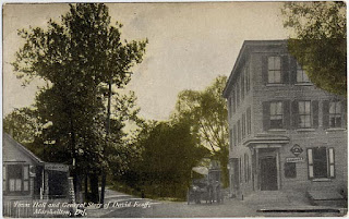
| Town Hall and General Store of David Ecoff |
I am keenly aware that most of what I do history-wise is a matter of compiling (and sometimes rediscovering) work that others have already done. Once in a while, though, I stumble across something that, at least to modern eyes, could be considered new. Something that, as far as I know, no one else around is aware of. I recently became aware that I have access to more old newspapers than I thought I did, so, naturally, I started nosing around. Not with any particular goal in mind, just sort of shotgunning any search terms I could think of. When I looked for Marshallton-related items, I came up with a few interesting pieces. And in the process, I think I've established some firm dates for two sites that I could only guess at previously.
The first location, which I'm sure anyone who's been through Marshallton will be familiar with, is the three-story brick building on the northwest corner of Duncan Road and Greenbank Road. It's had many occupants over the years, and is currently owned by Events Unlimited. The earliest image I've come across of it is the postcard seen above, which probably dates from about 1905 to 1910. At that time, the building (or at least the bottom floor of it) was home to the general store of David Ecoff. Ecoff was listed as a storekeeper in Marshallton as early as the 1880 Census, and was probably set up even a few years prior to that.
 |
| The Marshallton Town Hall today |
The question I've always had, though, was when exactly the brick building was built. The maps from the era are not precise enough to be helpful, and I've always assumed that Ecoff could have run his store from another location before moving to this site. My guess was that the "Town Hall" was built around the turn of the century. Oh yeah...and "Town Hall"??? That wording on the postcard always seemed a bit odd to me, too. Then I ran across the little entry seen below, found in the Wilmington
Morning News dated October 9, 1886. It's only three sentences, but it answers several questions.
 |
| From Wilmington's Morning News, October 9, 1886 |
I don't think there's any doubt from the description that the building described is the one that still stands. We know that Edwin Cranston did in fact own much of the land that is now Marshallton, including along Greenbank Road. So now we know who built the structure, as well as when. The note seems to be saying that the hall is either in the process of being built, or will be very soon. Either way, 1886 would appear to be the date of construction (maybe '87 if there were delays). The wording used also clears up the other question, at least in my mind. It was not so much a Town Hall, in the sense of a governmental building, as it was a hall for the town -- a place for public gatherings.
The timing also makes sense. John R. Bringhurst had purchased the Marshall's iron mill in the late 1870's, and through the mid-1880's made several enlargements to it. As grew the mill, so grew the mill town. Many of the beautiful houses lining the streets of Marshallton today were built during this period. Now we know that the town's hall also dates to this time of growth. And when an area expands, another aspect that needs to keep up is its transportation infrastructure. In this case, a bridge.
 |
| Marshallton's New Bridge |
The first bridge across the Red Clay in what would become Marshallton was erected sometime in the 1700's, when the Hersey family owned the nearby grist mill. Hersey's Bridge provided a vital crossing on the route from Newport to Hockessin and points north. There were several different bridges over the years, but the one we're concerned with today is the steel Pony Truss bridge shown in the photo above. More than six years ago I wrote
a post detailing the story of Marshallton's Travelling Bridge. New information has come to light which now makes fairly clear that one important point in that story is incorrect -- the travelling bridge was not the one from Marshallton. A new post will be written at some point to give the correct story, but for now I'll address a related point -- when this bridge was erected.
I've always dated the New Bridge photo to about 1905, and assumed that the bridge was built not long before that. Several newspaper articles I found have given a more precise date. Seems my guess of "about 1900" was pretty spot on. These three blurbs pretty much tell and date the story.
 |
| Wilmington Evening Journal May 1, 1900 |
 |
| Wilmington Morning News August 13, 1900 |
 |
| Wilmington Evening Journal December 12, 1900 |
The old bridge, which I believe was built in the 1850's (probably at the behest of the Marshall brothers), was showing its age by 1900. Local residents also hoped that a new, larger bridge would help alleviate the periodic floods that were occurring in the area. (How'd that work out, Marshalltonians?) While some locals fought for a new span, others were not convinced. There was even a whole to-do about a petition for a bridge, which opponents claimed included invalid names. Invalid as in some were not local residents, and at least one was dead. It seems like many of the opponents were non-Marshallton residents of White Clay and Mill Creek Hundreds who did not want to have to pay for the the new bridge.
In the end, the bridge was approved, bids were solicited in the summer of 1900, and work took place in December. One article stated that construction was pushed back so as not to interfere with harvest season. A temporary footbridge was put in place after the old bridge was removed and before the new one was opened. The new steel bridge would serve the village for more than a half century.
 |
| The Marshallton Bridge in 1921 |
In the original blog post about the bridge, I stated that it was moved in 1925. This is not correct. A new, concrete bridge did not replace the 1900 one until 1955. The photograph below, from 1938, clearly shows that the locals' hopes that the new bridge would stop the flooding were sadly misplaced. This picture is taken from Greenbank Road near Duncan, looking across the creek. If you look closely at the picture (clicking on it will help), in the mid-upper right just below the Coca-Cola sign, you can see the top of the bridge. Not only does this give you an idea of how high the water was, it also proves that the bridge was still there (and pretty secure). Fun how just a few offhand lines from an old newspaper can answer long-simmering questions.
 |
| Flooding in Marshallton, 1938 |


No comments:
Post a Comment