
through the course of their history, but there's one in particular that through much of the 19th Century had a bit of a split personality. The property in question has been known as Roseville for at least about 200 years, and sits (mostly) on the north side of White Clay Creek and west of Possum Park Road. Roseville has been featured in blog posts quite a few times: about the Roseville Cotton Factory, the nearby development of Roseville Park, the Roseville Covered Bridge, the Roseville Electric Plant, and about the Italian community at Roseville. There were also two posts about the Chillas family -- one about David Chillas and another follow-up about the Chillas family and their connection to the cotton factory.
Pretty much all of the posts and discussion about the Roseville property have focused on the very southwestern edge of it, along White Clay Creek. This is where the Roseville Cotton Factory was, and where the other various buildings stood that were related to it. However, this was not just a small mill lot -- the land it occupied was actually part of a larger 174 acre (and other amounts over the years) tract with a history that both predated and outlasted the industrial activity. That history got more than a bit convoluted at times, with multiple sales and lots of mortgages placed on it covering almost every owner, but I'll do my best to give a cohesive overview.
The history of the first 100 years or so of European occupation of the land is laid out very nicely in a deed from 1778. That deed, which records the sale from John Evans to James Black, shows that the first transfer (at least under English control) was back in 1683. In that year, William Penn warranted land (surveyed the next year at 300 acres) to Brewer Sinnexon, although I have a feeling that Sinnexon was probably already here. That tract lay on both sides of White Clay Creek, but in 1698 Sinnexon sold 100 acres on the north side of the creek (meaning, in MCH) to John Gardner. In 1701, Gardner sold the 100 acres to Cornelius "Neals" Cook, who also owned other land in the area.
In 1714, Neals Cook sold off his land in the area (some or all, I don't know), specifically two adjoining tracts. One was our 100 acres, which he sold to William Parsons. Directly to the north was another, 206 acre tract, which he sold to his son John Cook. However, 50 acres on the south end of that northern tract was separated off and sold to Parsons. Five years later, Parsons sold the 100 and the 50 acres to William McMechan. McMechan, in turn, sold them to his son James in 1734. What's interesting is that the two and a half story stucco house along Capitol Trail (Kirkwood Highway), which was damaged in a fire earlier this year (2023), is listed by the county as being built in 1735. If that date is accurate (and I don't know if it is, or even where the date came from), then it seems logical that it was James McMechan who built it.
 |
| A recent view of the purportedly 1735 house near the highway, possibly built by James McMechan |
The last piece of information included in the 1778 deed is that in 1760, the land was resurveyed. The 50 acre portion was found to be just a little more than that, but the "100 acre" tract was found to actually contain just over 181 acres. It says who did the survey (Thomas Woodward), but not who commissioned it, or who owned the land at the time. The next deed I've found is from 1765, when John and Mary Evans are selling the 231 acre (181 + 50) tract, along with four other various properties in White Clay Creek Hundred, to Samuel Platt. At least, I think they're selling them. The cost is only five shillings and there is language I don't fully understand about the use of it by the Evanses, so it may have been a legal or financial maneuver of some sort.
One notable thing about the 1765 deed is that it seems to be the first to indicate the existence of a grist mill and a saw mill on the property. They're mentioned at the very end, right after the 231 acre tract, which is listed last. And though the 1778 deed documents the previous sales, I've not been able to find any of them myself, so I don't know if the mills are referred to any earlier. All I can say with confidence is that the first mills were erected prior to 1765, but I don't know by whom -- and that sometime between 1734 and 1765, John Evans obtained ownership of the property.
Whatever that 1765 indenture was, it seems to have been reversed shortly thereafter, because in 1778 it was still John and Mary Evans who sold the farm to the new owner, Capt. James Black. Black was a leader of the community at the time, as well as a Revolutionary War veteran (well, participant in 1778). He owned multiple tracts of land in the area, including the property that would become the Eastburn-Jeanes complex. He also owned a number of properties between Roseville the Corner Ketch, including the one immediately north, which had the 50 acres sold out of it back in 1714. James Black bought that one in 1777 from Charles Black, who had gotten it from his father John. I have not been able to verify that James is related to those Blacks, but I assume that he was.
 |
| James Rice Black, son of Capt, James Black |
Capt. Black did not leave a will for his real estate, so after his death in 1796 the family ended up having commissioners appointed to oversee and dispense of his many holdings. Long story short -- the Roseville property ended up with his son, James R. Black (seen above). However, he was a lawyer, not a farmer or miller, so the younger Black looked to lease and/or sell his inherited lands. There were several ads over the years, but the most informative for us is the one below, from October 1810. The second half of the ad is referring to the tracts to the north, closer to Corner Ketch, part of which would become the Eastburn-Jeanes properties.
 |
| Sale ad from 1810. The first farm is Roseville. Half of the second will become the Eastburn-Jeanes farms |
The top half of the ad describes what would soon be known as Roseville, and mentions the "commodious" mill, "furnished with the modern improvements in the machinery". (The second property is the one near Corner Ketch, half of which would soon become Eastburn and Jeanes land.) The ad says it's in the vicinity of "the navigable waters of the Chesapeake and Delaware", which was true because the Christina River/White Clay Creek was indeed navigable all the way to Stanton. It also mentions a "large Brick Dwelling house and Kitchen", which is likely the house mentioned earlier, possibly built by James McMechan in 1735. It was mentioned in another ad as being "formerly the residence of James Black, esq. deceased". The other house on the property (seen at the top of the post), was a fieldstone farmhouse that I think came along soon after, and was related to the next major change at the site.
James R. Black did finally sell the property in 1811 to Isaac Price, but he only owned it for two years. It changed hands again in 1813, and this is probably where the history of this property diverged from that of other farms with grist mills. The new owner was William Newbold, a New Jersey-born merchant then living and working in Philadelphia. Although I don't have any concrete proof, it does seem like it was William Newbold, perhaps along with his brother John, who built the new stone cotton mill to compliment the old grist mill. Several clues point to the new factory being operational by at least 1816, and it seems that the Roseville name may have come from the Newbolds as well.
In 1815 there was an indenture between William and John Newbold which I first thought was a sale of the property, but which turned out to be a mortgage. There were seven adult Newbold children, and a number of transactions and business deals between them. Many of the deals concerned their property of Newbold's Landing in Red Lion Hundred, on which they laid out the plans for what would become Delaware City in the 1820's (with its position at the eastern terminus of the new C&D Canal, they hoped it would become a major port city). What's interesting about the 1815 mortgage is that John enters it as "guardian of John B. Bispham and William N. Bispham, minor children of Stacy B. Bispham." Stacy, who had died earlier that year, was the Newbolds' brother-in-law, married to their sister Ann. The mortgage was put in trust for the Newbolds' nephews.
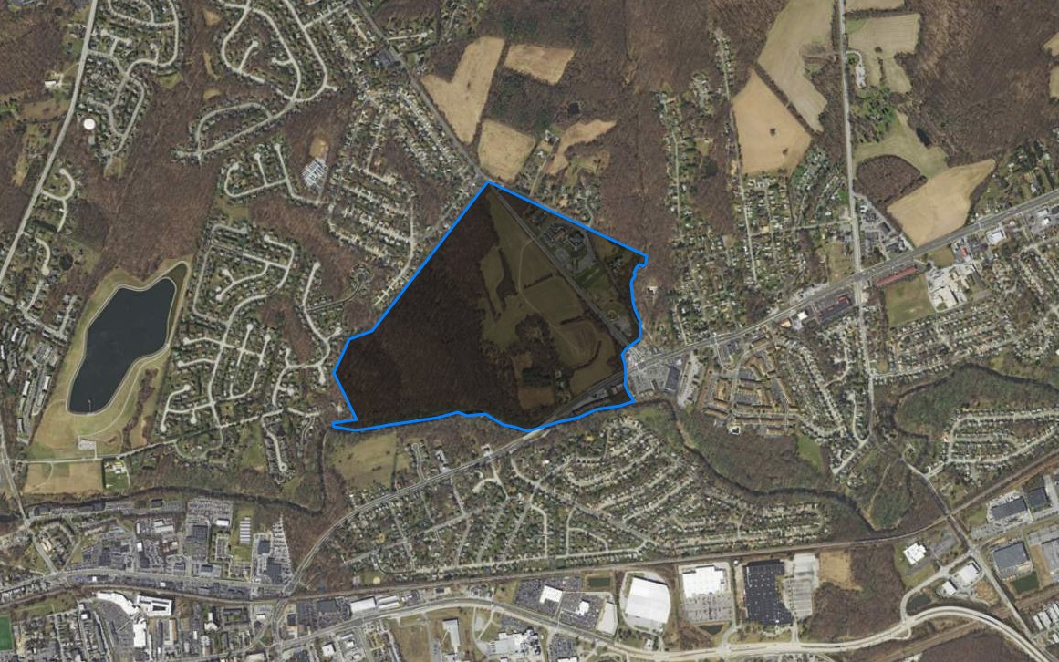 |
| Approximate outline of the Roseville Farm property. It changed a bit over time, but this is a general idea of what it encompassed. |
Unfortunately the Roseville property does not seem to have been particularly profitable (William took out another mortgage with a bank in 1819), and in 1828 John Newbold foreclosed the mortgage on his brother. The property was sold then by the sheriff to Harry Connelly, who was discussed a bit in the original Roseville post, and who we know was running the factory by then (he's named as the "terre tenant" in the 1828 sale). Since Connelly was running the cotton mill, and the mill was still part of the larger 174 acre farm property, there would presumably have been a tenant operating the farm. Since the 1830 Census doesn't give much personal information, we can only guess as to who it might have been then (Thomas Williams? Samuel Glasgow? Peter Fitzsimmons?).
The property was foreclosed on again in 1834 on a judgment against Connelly for George Thomas, now the guardian of the Bispham boys. I think this still all goes back to that original 1815 mortgage that had never been paid off. The new owner of the Roseville property was William Greiner, although he would not be for long. In 1836 Greiner sold the 174 acres to a man with a name well-known in the area -- Thomas Cooch. This Thomas was the great-grandson of the original Thomas Cooch, who settled in the area that would come to be known as Cooch's Bridge. Our Thomas paid for the tract with a $46,000 mortgage to John Pearson of Philadelphia, which would ultimately be his downfall here. He took another $6,000 mortgage the following year from his father, Francis L. Cooch.
It seems that the Roseville property was either consistently underperforming or regularly over-optimistically valued, because almost every owner defaulted on their mortgages at some point. There were a few things that happened during and just after the Cooch era that I don't quite understand. In an 1843 deed we'll get back to momentarily, it seems to indicate that Cooch defaulted on his mortgage back in 1838, and that the property was granted to John Pearson. However it states that it was determined that the property would not generate enough revenue in seven years to pay back the debt. However, in 1841 the Roseville Manufacturing Company was incorporated, and the property was described as being that of Thomas Cooch. It's possible that he was trying to transfer it to the company.
 |
| In 1843 Arthur Chillas appears to try to sell Roseville right after he bought it. He ended up not selling. |
However, in May 1843 the sheriff sold the now over 200 acres (23 acres on the south side of the creek had been since added) to Arthur Chillas, I believe to pay off Pearson. However, the price paid by Chillas at the public auction was 50 cents. Either the factory and property were in very bad shape and in need of great repairs, or there was something else going on. Chillas perhaps was never planning on keeping Roseville, as the ad above from June 1843 shows him putting it up for sale (with a great description of what was there). He must not have gotten any good offers, because Arthur Chillas did not sell the property in 1843. In fact, the family would end up holding it another 73 years.
In the next post we'll follow the history of the Roseville farm through the Chillas era and beyond, and bring us up to the present day.
I've been wondering about the kilns. I thought they just processed lime from Pennsylvania via Limestone road. Never knew there was a quarry in Delaware. Thank you for all your research!
ReplyDeleteYes, geologically, there just happens to be accessible limestone in the area (the kaolin clay is also related to this). I don't know if you found them, but if you look on the Index page under Eastburn, there are a few different posts from over the years. In this one here I took a shot at trying to explain the lime burning process -- http://mchhistory.blogspot.com/2011/01/brief-explanation-of-eastburn-jeanes.html
Delete