 |
| The Newport-Gap Pike bridge in its original location, 1921 |
To be fair, much of that post is correct, with two glaring exceptions -- I had the wrong bridge and an incorrect first move date. I think I realized that fairly early on, but I never got around to actually giving the correct information. However, very recently a commenter (thank you, Larry Davis!) asked about a story he had heard in his younger days, about how the Newport-Gap Pike bridge over Red Clay Creek at Greenbank had been repurposed somewhere else. That immediately rang a bell with me, and here we are. Yes, Larry, you were right.
It turns out that it was not the Marshallton bridge that has travelled around -- it's the Newport-Gap Pike bridge. They are very similar bridges, both being Pratt Pony Truss bridges. The Pratt Truss design was invented in 1844 and was one of the more common designs in the late 19th and early 20th Centuries, both for railroad and roadway bridges. The "Pony" designation indicates that the trusses are not connected at the top. I haven't been able to determine when this particular bridge was built, but I did find an 1884 newspaper article about New Castle County bridges that did indicate that there was an iron truss bridge in place at that time. It's quite possible that this is the same bridge.
 |
| Article detailing the plan to move and replace bridges, May 1930 |
We do have, however, a lot more details about the later moves for this bridge. Although the Pratt Truss bridge was a substantial structure for the horse-drawn traffic of the late 19th Century, the automobile traffic of the 20th Century required a stronger and wider bridge. In 1930 it was announced that the Levy Court would be accepting bids for a new, concrete bridge to be built, carrying the turnpike across Red Clay Creek. But since the old bridge was still in good shape, it would not be wasted. It would itself be an upgrade, a few miles upstream at Mt. Cuba.
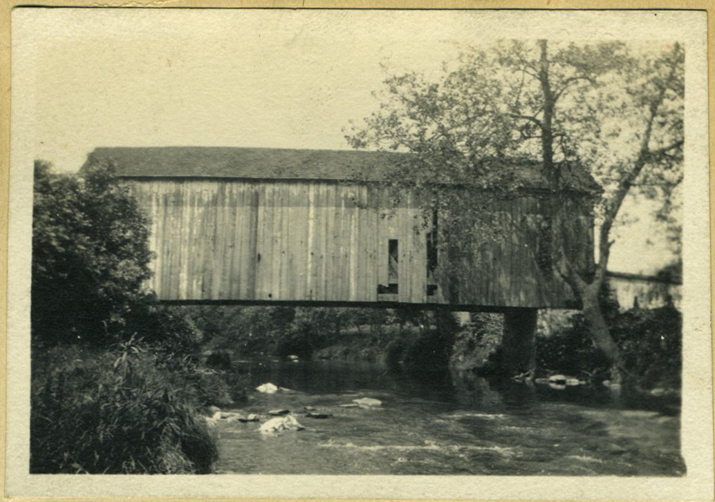 |
| The c.1856 Mt. Cuba Covered Bridge, 1921 |
The winning bid for the work came from the Luten Bridge Company of Clarksburg, WV. The new bridge at Greenbank would be constructed for $11,393.75, and the old bridge would be moved and re-erected at Mt. Cuba for $1622.80. It would be replacing the old Mt. Cuba Covered Bridge, said to have been built around 1856. And like the iron truss bridge at Greenbank, the old covered bridge was no longer sufficient for the needs of the road. Even in 1930, people were bemoaning the loss of covered bridges. A contemporary article states that after the removal of the Mt. Cuba Covered Bridge, there would be only eight more remaining in New Caste County. (I know you're wondering -- Smith's, Thompson's, Rockland, two at Ashland, Wooddale, Paper Mill, and Red Mill.)
By early August 1930, the bridge had been moved and was open to traffic at Mt. Cuba. There it would stay, for the next forty years. Then, in 1970, the bridge was again on the move. Instead of being disassembled and reassembled as it was in 1930, this move was done in one piece, by helicopter. It was airlifted about 4,00 feet from its span of Red Clay Creek to its new home, spanning Barley Mill Road. And this time there was no concern for its load-bearing abilities, because it was no longer being used by vehicular traffic.
 |
| News of the bridge move, April 1970 |
Instead, the bridge (which by this point may have already been almost a century old) was to be used for pedestrian traffic. The new owner of the bridge was Lammot du Pont Copeland, owner of the Mt. Cuba estate. Although it wouldn't happen for many years, Copeland was already looking ahead to a day when Mt. Cuba would be open to the public, and he wanted a safe link between it and the Delaware Nature Center (also in its formative years) on the other side. Over a half century later, now with both sides part of the Mt. Cuba Center, the bridge still sits atop Barley Mill Road. So next time you ride down the road there and pass under it, know that the bridge over your head once carried horse-drawn wagons and carriages over the creek at Greenbank, and motor vehicles at Mt. Cuba. And now we finally have the correct story.
 |
| The bridge as it looks today, spanning Barley Mill Road |
Great read. I used to pull off the road and walk up there about 15 years ago, the field is a nice view especially at sunset
ReplyDeleteso whats the story on the iron bridge Greenbank Road by the Greenbank mill history there by any chance?
ReplyDeleteThe old 19th Century bridge that was there, and was Greenbank Road, was washed out in 2003 by Tropical Storm Henri. In 2010 a similar bridge was moved from Chester Heights, PA. That's what's there now. Similar age and type to what was there, but not the same one
DeleteScott thank you for the imfo
Delete