As the title suggests, this is more of a collection of thoughts that just occurred to me than a well thought out post. Why it just occurred to me today, you'll see towards the end of the post. Perhaps some future research could more fully flesh out these ideas, but for now here's some things to think about as we move through what for us today is the back end of the Holiday Season.
I don't believe that I've ever come across any firsthand accounts of holiday celebrations in MCH in the 1700's, but I think we can make some fair assumptions. As we've seen, there were three major cultural/religious groups in MCH in the 18th Century. Yes, there were still some Swedes, Danes, and their descendants, but primarily the area was populated by English Episcopalians, English Quakers, and Scots-Irish Presbyterians. In thinking about this, I realized that these three groups celebrated the holidays in very different fashions from each other.
Of the three groups, the "proper" English settlers who still held to the Church of England (the Episcopal Church, in America) celebrated the season in the way that would look the most familiar to us today. The Christmas Season was a religious holiday first, but was also a time of family, decorations, and celebration. A good account of an 18th Century English Christmas can be found here. One interesting note is that for them, Christmas was the beginning of the holiday season, not the end. MCH Episcopalians would have gathered at St. James Church near Stanton to celebrate all of the holy days falling in the 40 day season of Christmas.
Thursday, December 31, 2015
Monday, December 14, 2015
John "The Boyne Water Major" Montgomery and Family
 |
| The property of John Montgomery |
There was, for instance, an Alexander Montgomery who ran the Rising Son tavern in Stanton in the early days. There was also an Alexander who co-founded the first mill in Milltown in 1747. They may or may not have been the same person. A Samuel Montgomery purchased land from the Robinsons near Milltown in 1766, and William Montgomery built the house that still stands along Old Limestone Road, over 200 years ago. Again, these men may or may not (I think they probably were) have been related -- there's just no good data I've come across yet to make a firm connection.
Although all of these Montgomerys deserve to have their tales told (and hopefully I'll be able to do that someday), right now I'd like to focus on a different (and apparently unrelated) branch of the clan. This line of the family has its own rich heritage, and thanks to some typically fabulous work by old deed-miner extraordinaire Walt Chiquoine, we have a pretty decent grasp on who they were and where they lived. And as a bonus, I hope to have an interesting follow-up to this story sometime in the near future.
Thursday, November 5, 2015
A Couple New Picture Additions to the Collection
 |
| William "Dutch Billy" Losien, 1921 |
The first picture is one you might have seen alluded to in a comment recently, and it kind of blew my mind when I saw it. I honestly never even considered the possibility that we might one day have a photograph of this man, but here we are. The picture was taken near Pleasant Hill (south of Corner Ketch) in 1921, and comes to us from Rob Hobdell, the grandson of the original photographer.
Friday, October 23, 2015
The Hanna Family
 |
| The Hanna Family, c.1910 |
If we're really lucky, the photo will come with good information as to who or what is shown. A lot of times, though, the accompanying information can be frustratingly sparse. It might give the general location of a house, but not the exact location. Or we might know what family the subject of a photograph is from, but not exactly (for sure) who they are.
These are the issues I ran into with a couple of pictures sent to me a while back by Donna Peters. There's a photograph of an old house, and one of four people (and a dog) on what's obviously the porch of that house. We knew that they belonged to the Hanna family, but, initially, not much more than that. After going around and around for a while (and thoroughly confusing myself in the process, not that that's a high bar), and with the last-minute help of a few additional pictures, I'm confident that I know who the people are. The house, though, is a different matter. We'll get to that in a moment, but first, the people.
Wednesday, September 23, 2015
The Magical 1948 Map
 |
| Lower left quadrant of 1948 map |
The two exceptions to this that I've come across are the circa 1941 New Castle County Bus Map and the 1948 map shown here. This is actually only a quarter of the entire map, the lower left quadrant to be exact, it doesn't have names of property owners like the earlier ones, but there are several things on and about it that make it interesting enough to take a closer look at.
First of all, it comes from a transitional time in the history of Mill Creek Hundred (and the rest of the Wilmington suburbs, for that matter). 1948 was right near the beginning of the post-war suburban expansion in MCH, and the map reflects that. There are a few new developments shown (Kiamensi Gardens, for example), but not many. You can see the suburbs expanding out of Newport and Elsmere, but for the most part things are pretty clear west of the Red Clay.
Thursday, September 17, 2015
Mitchell Station -- Part 2
In the last post, Guest Blogger SteamCarriage mentioned an odd artifact found in the fields of Jim Mitchell's Woodside Farm southwest of Hockessin, with the date of 1892 on it. He gave us an excellent background on the creation and evolution of Delaware's (and Mill Creek Hundred's) unique, curved northern border. In this post, SteamCarriage will delve deeper into the events of 1892, and explain exactly how this MCH hill was used. Now, the exciting conclusion of Mitchell Station...
--Researched and written by SteamCarriage
--Researched and written by SteamCarriage
 |
| Stone found in the fields of Woodside |
United
States Coast and Geodetic Survey
It took nearly 40 more years before another
Commission sought out the United States Coast and Geodetic Survey (an early
version of the US Geological Survey) to resolve the matter. The Survey appointed William Chandler
Hodgkins to lead the project. The United
States Coast and Geodetic Survey published a very detailed report titled “A Historical
Account of the Boundary Line between the States of Pennsylvania and Delaware”
by W.C. Hodgkins, dated December 1, 1893.
The 52-page report is available online through Google Books and well
worth the read for anyone wanting to know the particulars of the survey. It is part of the Report of the
Superintendent of the US Coast and Geodetic Survey for the fiscal year ending
June 30, 1893 (in two parts).
After initial field work, Hodgkins discovered two
circles would best define the northern border between Delaware and Pennsylvania
and he proposed a solution to the Commission.
They accepted Hodgkins’ analysis and he completed the official boundary survey
in 1892-1893 defining the eastern arc boundary of Delaware and Pennsylvania
along with the intersection of the Delaware-Maryland border. The Wedge became part of Delaware and the
Delaware-Pennsylvania arc border is a complex arc defined by two different
radius arcs with neither center point at the New Castle Court House (but very
close).
Tuesday, September 15, 2015
Mitchell Station -- Part 1
Time for another guest post, this one from a new contributor, SteamCarriage. It's about a subject I've always meant to get around to, but never have -- Delaware's unique northern boundary. What's neat about these posts are how they tie the topic in to MCH with a specific object and site, located on a historic property previously covered here. Thank you, SteamCarriage for all your work, and enjoy!
-- Researched and written by SteamCarriage
While working a field on one of the higher locations of Woodside Farm, owner Jim Mitchell uncovered a flat square stone that had long been buried. On it was chiseled a triangle with a hole in the center along with the markings “U S 1892”. Under the stone Jim found a clay urn with a square iron spike secured in the center that aligned with the hole in the cover stone. Jim shared the find with the author and asked if we could determine the stone’s origins, use, etc. After some research it was learned that Mitchell Station was a point selected by the United States Coast and Geodetic Survey in 1892 for the purpose of settling, once and for all, the disputed 12-mile arc boundary that existed between Pennsylvania and Delaware. What follows is a brief history of how the dispute came to existence and how the stone came to Woodside Farm as a key element in the process the US government used to resurvey and establish the 12-mile arc boundary putting the matter to rest in 1892-3.
Delaware, Pennsylvania, and Maryland
The first settlers arrived to the lower shores of Delaware in 1631. In 1632 King Charles I granted Cæcilius Calvert, the second Baron of Baltimore, a large estate between the 38th and 40th parallels of north latitude. The land included the present states of Delaware, Maryland, and the lower portion of Pennsylvania. In 1664 King Charles II granted his brother, James Calvert, the Duke of York, all the lands between the Connecticut and De la Ware (Delaware River as it is known today) Rivers which encompassed parts of the present states of eastern Pennsylvania, eastern New York, and most of New England and included the colony at Newcastle (New Castle, Delaware as we know it today).
-- Researched and written by SteamCarriage
 |
| Stone, urn, and spike found in the fields of Woodside |
Delaware, Pennsylvania, and Maryland
The first settlers arrived to the lower shores of Delaware in 1631. In 1632 King Charles I granted Cæcilius Calvert, the second Baron of Baltimore, a large estate between the 38th and 40th parallels of north latitude. The land included the present states of Delaware, Maryland, and the lower portion of Pennsylvania. In 1664 King Charles II granted his brother, James Calvert, the Duke of York, all the lands between the Connecticut and De la Ware (Delaware River as it is known today) Rivers which encompassed parts of the present states of eastern Pennsylvania, eastern New York, and most of New England and included the colony at Newcastle (New Castle, Delaware as we know it today).
Wednesday, September 9, 2015
Help with the Sinclair Station and/or Campbell's Store
 |
| Location of Campbell's store, next to the library |
The most recent query relates to a property that apparently served numerous roles during the early to middle part of the last century. It's a white house, with some obvious additions added on over the years, located on the northeast corner of Old Capital Trail and Wollaston Road, directly across Wollaston from the Kirkwood Highway Library. Anyone who's gone to the library over the years has gone right by it countless times but, like me, probably had no idea that the house had it's own unique history. Problem is, we're not real sure exactly what that history is.
A family member of the current owners contacted me and asked if I knew anything about the history of the property. I don't, but we're hoping someone out there does remember something. The current family came into the property in the mid-to-late 1950's, when it was purchased by Vickers (Vick) and Mary Campbell. They had previously lived on a farm near Richardson Park Elementary, but decided to buy this property instead of that farm.
Thursday, September 3, 2015
The Forest Oak District #35 School
 |
| Forest Oak School #35, in 1926 |
The exact early history of the Forest Oak School is not well-documented (at least not that I've found), but a general timeline can be inferred from other sources. The school that preceded Forest Oak as the District #35 school was also on St. James Church Road, but a little further south. Initially founded in 1808, the St. James School was located across the road from the church of the same name. After the passage of the Free School Act in 1829, the subscription school became the District #35 public school. Although the school house remained standing until 1915 (when it was torn down and stones from it used to build a sexton's house, which now forms part of the parish house), it had long since ceased to be a public school. When, exactly, I can only somewhat narrow down.
Thursday, August 27, 2015
A Couple of Old Stanton Schools
 |
| Stanton #38 School, 1928 |
Some other things that can make a newly-discovered picture interesting are if it shows a structure you're familiar with in a different state or condition, or if it provides new information about the building. It's these last two that prompted me to want to share a couple of old photographs of some neighboring buildings in Stanton. Of the two buildings, one is long gone, as should be obvious from the picture itself. The other is still standing, although heavily altered and looking very different than it did 85 years ago, when the two briefly shared a bond besides their close proximity -- a bond I only became aware of because of one of the pictures.
Friday, August 21, 2015
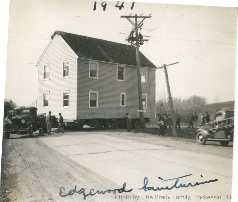
Two Lost Houses from the Brandywine Sanatorium System
 |
| Nurses' Home on the move, 1941. From the collection of James and Anita Brady |
The first case has to do with the picture above, which was sent to me a while back by James Brady III. It was taken from one of his grandmother's photo albums, but at first neither he nor I knew anything more than was readily obvious. It's from 1941, of a house being moved, and has something to do with the Edgewood Sanatorium. The only thing I could add at first was that Edgewood was the "Colored" facility, for African-Americans with tuberculosis. It was located not far from Brandywine, on the bend in Hercules Road, at the top of the hill.
Tuesday, August 18, 2015
The State Industrial School for Colored Girls
 |
| The rear of Denney Hall |
In the late 19th and early 20th Centuries, the issue of how to deal with delinquent minors was just beginning to be addressed in a more modern way. Instead of going to prison, children (mostly teens) were sent to Industrial Schools to (hopefully) be reformed, educated, and reintroduced as productive adults. In Delaware, both white and African-American boys were remanded to the Ferris Industrial School on Center Road (Rt. 141). White girls ended up at the Industrial School for Girls, later called the Woodshaven School, on Darley Road in Claymont. There was, however, two decades into the last century, nowhere in Delaware set aside for the care and rehabilitation of girls of color.
Friday, August 7, 2015
The Kiamensi Garage and Inspector's Dwelling
 |
| The Delaware State Highway Department's Kiamensi Truck Storage Shed, in 1941 |
Amongst this new stuff were a few really cool pictures that I had never seen before, and that in a few cases raise more questions. On the plus side, at least one lingering question has been (mostly) answered and one site I'd only kind of known about is shown in great detail. These pictures all come from insurance evaluations done in 1941 for government-owned facilities, like schools, armories, medical facilities and such. I'll roll out some of these over the next couple weeks, but we'll start here with two related photographs, one of which I'd seen something similar to before and one of which was new to me.
Wednesday, July 29, 2015
Still on the Trail of the Stone Troughs

Those finds proved that the troughs at Delcastle were not unique, which made me even more sure that there had to be more out there. Well, we've got another one. Like the others, this one is located nowhere near Delcastle -- it's found in the yard of a house on Smith's Bridge Road near Granogue, in Chateau Country, northeastern Christiana Hundred. The house itself only dates to 1957, so the current owner (thanks for sending the pics!!!) believes that the trough was purchased and placed by the previous owner.
Thursday, July 23, 2015
Photo of Robert L. Armstrong's Hedgeland
 |
| Armstrong House known as Hedgeland |
Hundred (and MCH-adjacent) history. This particular item is the photo you see here, sent to me a little while back by a descendant of the family in question (as well as several other families oft-mentioned in the blog), Nancy Lynam. Although the house did not technically stand within the boundaries of Mill Creek Hundred, it was featured in a post detailing the familial holdings of the Armstrong clan, located in western Christiana Hundred. And though the house was lost long ago, it stood in a prominent location, one I'm sure many of you have passed countless times (perhaps some of you on your way in to work every day).
The beautiful five-bay, two and a half story, fieldstone home shown here was the house known as Hedgeland, or The Hedge. It was located on the east side of Centre Road (Rt. 141), just north of Faulkland Road. The segment of the 1881 map below shows the estate. The house itself, as best as I can determine from historical aerial photographs, stood right about where the flag pole is today, at the South 141 entrance to DuPont's Chestnut Run Plaza. This part is even more iffy, but it appears that the house faced south, perpendicular to 141 and facing down towards Faulkland Road. The blue rectangle in the bottom, modern photo indicates approximately where the house stood.
Wednesday, July 15, 2015
William Guest (Part 2) -- Owner of Cuckoldstown
 |
| Did you know what it meant? |
Researched and Written by Walt Chiquoine --
In my prior post, I introduced you to William Guest, an affluent and educated guy who settled in MCH in 1682. We know he was an attorney, judge, and representative, and he finally settled on a large tract that includes today’s Stanton. After years of litigation, he gained full control of the first mill seat at Stanton from Cornelius Empson. The mill property was sold by Guest’s estate in 1720. So for a number of years, William Guest lived in Stanton and managed the mills and tenants on his property. He must have been a very public figure to his peers at court and to his humble neighbors.
William Guest may have left another legacy for early
Stanton. We know there are 18th
century references to the area as Cuckoldstown, and I’ve agreed with Scott
Palmer and others that this could have originated as Cocclestown for the shellfish that were plentiful in the creeks and estuaries. Other historians suggested the name may have
come from an Inn that hosted adulterous trysts, but that of itself seems an
inappropriate use of the term cuckold. And
it just doesn’t seem that noteworthy since it was probably true of many taverns,
and I struggled with that explanation.
A cuckold is a husband that suffers or tolerates (or even
encourages) his wife’s promiscuity in a way that is publicly known. Then and now, I imagine it happens pretty
regularly, but to name a village for it?
It’s a derisive and condescending label.
I assume it would require the cuckold and the cuckolding to be a
well-known person that involved well-known events, something that really stood
out in people’s minds like a bad joke, something to gossip about. Could the cuckold be William Guest, in the
sense that it was his Cuckold’s Town? Not the plural, but the possessive…
Monday, July 6, 2015
William Guest (Part 1) -- Owner of Stanton Mill
 |
| William Guest's Wedgebury Tract |
Researched and Written by Walt Chiquoine --
I thank Scott for another chance to talk about some of our earliest history in Mill Creek Hundred. This time, it’s about William Guest, a gentleman from West Bromwich, England who immigrated with the fleets of William Penn. Early historians list him on the Hester and Hannah, arriving at New Castle in August of 1682. Guest settled immediately in Mill Creek Hundred (MCH). And despite his appearance in the same year as Penn, he was not Scots-Irish nor was he a Quaker.
William Guest did arrive as a fairly affluent and well-educated
man, since he immediately engaged in legal and civil affairs. I have not found his date of birth, but I’d
guess he was around thirty – he certainly wasn’t afraid to mix it up in court with
his peers, as a deputy to William Penn described him as “naturally passionate”
in 1686. Within a year of his arrival,
Guest was elected to Penn’s Assembly as a representative from New Castle County
(1683). He later served as a judge for
the Court at New Castle. Guest left an
incomplete legacy in his deeds and personal records; in what we have, there is
no mention of an early wife or family. But he may have a role in explaining two
mysteries: what happened to the first
grist mill in MCH, and where did the name Cuckoldstown (early Stanton) come
from?
In this post, I’d like to introduce you to William Guest and
talk about the first Stanton mill. I’ll
follow with a separate post on Cuckoldstown. (Second post can be found here.)
Friday, June 26, 2015
The Early History and Impact of the Wilmington & Western Railroad
 |
| Invitation for the inaugural WWRR train, Oct. 19, 1872 |
There were three railroad lines built through MCH in the 1800's, two along its southern portion and one up its eastern side. The two southerly ones -- the PW&B (later the PB&W, now the Amtrak line) and the Baltimore and Ohio (now the CSX line) -- were just portions of much longer lines. There were stations here, but mostly they just passed through, sort of like I-95 through Delaware today. The third line, though, weaving its way along Red Clay Creek and then away to the northwest, was much more of a local business and passenger line. More Kirkwood Highway than I-95. This was the Wilmington & Western Railroad, and it was a good example of how a business can be important without being, itself, particularly successful.
Monday, June 15, 2015
The Changing Face of Milltown
 |
| A bridge on Milltown Road, 1921 |
To be honest, this is one of those topics I had neatly avoided for years, primarily because it always seemed like more trouble than it was worth. I kind of understood what had happened, but it never completely made sense to me. Recently, however, with the help of Bob Wilhelm (who grew up very near the intersection), it all now seems much more clear. Hopefully it will to you, too, when you're done reading the post. It draws heavily upon Bob's recollections of his youth, and I thank him greatly for his help.
Monday, June 8, 2015
The Changing Face of Mill Creek Hundred
 |
| Section of Lincoln Highway (Kirkwood Highway) in 1918 |
Once Europeans began settling MCH in the early 1700's, the face and general feel of the area didn't really change all that drastically for the next 200 years or so. Sure, the large tracts of the first settlers were broken up, farms got a little bit closer, and some new industries popped up here and there through the 19th Century, but all in all, I don't think someone from 1720 would have felt all that out of place walking around in 1880. Heck, he would have even recognized a lot of the names! The 20th Century, however, was a whole new ballgame. (Literally. Baseball historians use 1900 as the start of the Modern Era.) Take someone from 1880 and drop them on Kirkwood Highway in 1965, and I'd bet they'd be a bit taken aback.
Friday, May 29, 2015
William H. and Anna Walker Photos
 |
| William Hicks Walker |
However, since I think all of these photographs are fascinating in their own rights, I want to at least give a very short post to even the photos going onto old posts, just to make sure everyone is aware of the new additions. I'll be putting some of these up over the next week or two, starting now. The first new pictures we'll take a look at are of folks mentioned (or at least, he was) in a post from three years ago, about a family that was the source of an unusual place name in MCH.
Wednesday, May 20, 2015
Ward-Dudkewitz House
 |
| The Ward-Dudkewitz House |
Instead of reprinting the entire article again, I'll refer you back to the original post if you're interested in the whole thing. Right now, we're essentially only concerned with part of one sentence. After mentioning that the house where Washington met was "the old Harlan property, now belonging to Mr. Allen Ward", it tantalizingly notes that "...the present owner has erected a substantial brick dwelling adjoining...". So I started thinking -- Harlan property in Milltown, brick house built in the 1850's....it must be the recently fire-ravished Abram Chandler House! It's usually given a build date closer to 1870, but there's a fair bit of ambiguity about the property in that time period. My second thought was, "Who the crap is Allen Ward?" We'll get to that second, elegantly phrased question in a moment.
Thursday, May 7, 2015
Diamond State Kaolin Company

First there was the milling and shipping center of Stanton (or Cuckoldstown for you oldtimers), prominent in the late 18th and early 19th Centuries. Then, as it started into decline, the manufacturing village of Marshallton (along with nearby Kiamensi) rose for a time in the mid to late 1800's. Finally, although it had been around in some form since the early 1700's, the northern MCH village of Hockessin became the "place to be" in the later 19th Century. Two of the biggest reasons for this Hockessin Golden Age had to do with the land, namely what was under it and what was built across it -- kaolin clay and the railroad. Recently I ran across a photo of an artifact that sits squarely in the intersection of the two. (Thanks go to Bob Wilhelm for identifying the background of the company involved.)
Tuesday, April 14, 2015
General Washington in Milltown

ONE OF THE RELICS. - It is said that General Washington and Staff held a council of war on the evening previous to the battle of Brandywine, in the house on the old Harlan property, now belonging to Mr. Allen Ward, in the Milltown, Mill Creek Hundred. The room pointed out for this important conference is little more than ten by twelve feet, and is still in good repair. Although the present owner has erected a substantial brick dwelling adjoining, we presume he intends to preserve this momento of the days of the revolution. The American army was posted in great force at this point, as the British were expected to take the route to Philadelphia, but they changes there course, keeping farther to the north, and the Battle of Brandywine, at Chaddsford, was the result. The house alluded to above, is built of logs, dovetailed together, which are in a remarkably good state of preservation; there are four rooms and a passage on the first floor, and five on the second, with a garret above; the floors are oak, and although they are said to be 112 years old, look as though they might last for a century to come. Attached to the ceiling, in the entry, is a three cornered box, which is of the shape of the military hat worn in the revolution, and it is generally supposed that it may have held the chapeaux of Washington. The descendants of the Harlans may know something of his history, and we have no doubt that they might furnish an interesting chapter in regard to it.
Wednesday, April 8, 2015
The Mill Creek Hundred Blanket, or Banner, or Something
In a perfect world, I'd have time to scour through yard sales, resale shops, and antique shops looking for MCH-related items (and have the money to buy them, but one fantasy at a time). With the mental catalogue I've put together the last few years, I'd have a decent chance at recognizing relevant items. I'd mostly have to be looking for recognizable structures (in photos) and names of businesses and families to link them to MCH. You wouldn't normally expect an item to just have "Mill Creek Hundred" written across it in big letters, right? Except, of course, for when it does. Like now.
Thursday, April 2, 2015
Yet Another Stoney Batter Theory
 |
| Was this Stoney Batter? |
In the Walker post, I mentioned that there had been a Historic American Buildings Survey (HABS) report done on the property at one point, but that only the photographs (and not the data pages) were posted online. Since I hadn't checked it in a while, I figured I'd look to see if the rest had been posted. Unfortunately they have not, but in looking at the entry I noticed something that I probably hadn't before, or at least it didn't seem important before. It may not end up meaning anything, but I thought it warranted some looking into. What I noticed was that while the HABS report officially lists the property as the J. Walker Farm, under "Other Title" it lists Stoney Batter House. (insert dramatic "dun dun DUN music here)
Wednesday, March 25, 2015
Stoney Batter Update
 It didn't take long for a few good pieces of information to come in relating to the mystery of the origin of the name "Stoney Batter Road", introduced in the last post. Neither of them come anywhere near conclusively answering the question, but both give (or potentially give) us a bit more information. Interestingly, each addresses a slightly different aspect of the riddle.
The first item, forwarded to me by Donna Peters, is the birth certificate seen here. It belongs to George Lilburn Gray, born April 15, 1888. The certificate itself, however, wasn't issued until 1941. What's relevant to us right now is that in the mother and father's residence field, and in the place of birth, is listed "Stoney Batter, near Stanton". So not only do we have a verified pre-war mention of the name Stoney Batter, it seems to be used as a place name, not a road name.
Friday, March 20, 2015
Stoney Batter Road
 |
| See? No name. Ugh. |
This uniquely-named thoroughfare is located near the center of Mill Creek Hundred, running from Limestone Road at the Mermaid Tavern, eastward down to Mill Creek Road. Or to put it in more modern terms, it's on the north side of Goldey-Beacom College. It's also known as Mermaid-Stoney Batter Road. I'm sure many of you are as familiar with this road as I am, and I'm equally as sure that you've wondered just were the heck the name came from. I wish I had a good, definitive answer for you, but as of now I don't. Maybe someone out there has information pertaining to the naming of the road, but I've looked around and I can't find it. What I do have are at least three separate, inconclusive theories.
Thursday, February 26, 2015
Final Red Clay Valley History Talk
 The third and final talk in the Red Clay Valley History series (for this year, at least) will be held on Monday night, March 2, at 7:00 PM. As with the others, it's taking place at the Wilmington & Western's business office on Railroad Avenue in Marshallton. The topic this time is the history of the Wooddale area, and it's being presented by....wait, who was that again?....oh right, me. It will cover some ground already included in previous blog posts, but tied together and with some additional information.
Should be a fun evening, hope to see you there! If you'd like to RSVP, you can do it here.
Wednesday, February 18, 2015
Brandywine Springs Park Request
 I just found out recently that New Castle County has decided to tear down the main pavilion at
 Brandywine Springs Park and rebuild a new one. For those familiar with the park, this would be the larger pavilion down the hill from the parking lot, as seen here. Apparently it is suffering from structural problems that are too extensive to economically fix, so NCC has determined that it's more cost effective to just replace it.
I've had some fun there, but the pavilion itself is not particularly historically valuable, so I don't have any problem with them putting in a nice, new facility. The existing pavilion was built in the 1950's, when the park, originally a State Park, first opened. And as those of you who have been around here a while may recall, it was not originally alone. When Brandywine Springs State Park opened, there was another building that stood in front of the pavilion, just to the left of the photo above. This building contained the park office, along with restrooms. We're not quite sure exactly when this office was removed, but some recall it still being present as late as the mid-1980's.
Now here's my challenge to you -- Does anyone have any more information, any fond memories (that would be suitable for a family blog), or any old photographs of the office or the pavilion? More specifically, does anyone remember exactly when the office was torn down? Any special memories of the pavilion to help eulogize it? And does anyone happen to have any pictures that might happen to show the office in the background? I realize that it's unlikely that you would have taken just a picture of the office, but maybe it might be visible in the background of a shot from a picnic, or a party, or a family reunion. Thanks!!
Friday, February 13, 2015
The Barker Mill Site
 |
| Barker Sawmill race, 1895 |
But now that I've spent more than five years just combing through Mill Creek Hundred related history, there's one other thing I can add. I have a fairly decent memory, and once in a while as I'm researching a particular topic I'll stumble upon something related to a subject I'd covered in the past. A name, place or word will jump out at me, and I'll have to go back and see if it's truly new information. It may even be something I had seen before, but had failed to recognize the significance of until after I had done an investigation.
Tuesday, February 3, 2015
Save the Eli B. Talley House!
 |
| The E. B. Talley House on Mt. Lebanon Road |
The beautiful, whitewashed stone house sits on the north side of Mt. Lebanon Road just off of Concord Pike (Rt. 202) in Talleyville. Mt. Lebanon Road is the one heading west near the Talleyville Fire Comany, the post office, and the big Taco Bell. The house is on the right, just past the Boston Market, the Brandywine YMCA, and the Brandywine Valley Baptist Church. The three-bay, two story home, of course, long predates any of these, having reportedly been built in 1814.
Monday, February 2, 2015
Red Clay Valley History Talk -- Mt. Cuba Center
A last-minute reminder that the second in the series of Red Clay Valley History Talks is tonight, February 2, 2015. The topic of tonight's talk is the Mt. Cuba Center, it's gardens and grounds. The event begins at 7:00 PM, the doors open at 6:30. Admission is free, but donations will be accepted to help benefit Historic Red Clay Valley, Inc. The lecture is being held at the Wilmington & Western Railroad's business office building, on Railroad Avenue in Marshallton -- not at the Greenbank Station. A map and directions can be found here.
Looks like the weather gods cooperated again, so hope to see you there!
Looks like the weather gods cooperated again, so hope to see you there!
Tuesday, January 27, 2015
Two Losses and the Case for Vigilance
 Now we get to what was supposed to be my third and final "catch up on stuff I'd missed" post,
 following the posts about the Coffee Run site and the Byrnes Mill Dam. With the news I received over the weekend, though, this is now going to be a much different post. Less of just reporting some news, and more of getting up on my soapbox and trying to ease my own conscience.
I was originally simply going to report the now almost two month old story of the loss of the Abram Chandler House on Limestone Road in Milltown. The house (which was one of the first sites featured on the blog, nearly five years ago) had been vacant for several years, and the blaze has since been determined to have been arson. It was apparently in pretty bad shape even before the fire, and according to the News Journal article the owners could not be contacted. Under the circumstances it's hard not to be very suspicious about some sort of insurance situation, although as far as I know no suspects have been named.
Wednesday, January 21, 2015
Byrnes Mill Dam Removal
The second recent news item I'd like to catch up on is the one I described in the last post as "good news that at first might seem like bad news". Back in the middle of December, an article appeared in the News Journal about the intentional partial destruction of a structure more than 220 years old. Normally that would be tragedy, but in this case the structure in question was a dam on White Clay Creek that fed a mill associated with the Hale-Byrnes House. The dam is located amidst the White Clay Creek Country Club golf course (Delaware Park), and was removed for a very good reason.
The following article was written especially for us by Jerry Kauffman, University of Delaware professor and director of UD's Water Resources Agency. I'd like to thank Dr. Kauffman for providing us with this, and for all his work in local environmental and historical preservation.
The following article was written especially for us by Jerry Kauffman, University of Delaware professor and director of UD's Water Resources Agency. I'd like to thank Dr. Kauffman for providing us with this, and for all his work in local environmental and historical preservation.
Thursday, January 15, 2015
New Life for Two Old Sites
 Now that my own life is starting to get back to a regular rhythm and I've completed (for now) my two month trek through the Cranston family tree, it's time to catch up on a few news items that have popped up recently. I'm sure that many of you have seen some or all of these stories, but I'd like to take the opportunity point a few of them out and say a few words of my own. Of the three I want to bring up, we've got good news, bad news, and good news that at first might seem like bad news.
The first one is the most recent story to appear, showing up in the News Journal on Monday, January 12. According to the article, Trinity Community Church, which recently purchased the Coffee Run Church site on Lancaster Pike, will submit plans to once again have a place of worship on the site of Delaware's first Catholic Church. Trinity founder Steve Trader feels that the property is holy ground, and that, "God made this a church."
Friday, January 9, 2015
The Sons of Simon Cranston -- Part II
 In a recent post, we looked briefly (and not so briefly) at six of the eight children born to Simon and Mary Cranston of Stanton, Mill Creek Hundred. Covered were William, Joseph, Mary Ann, Eliza, Samuel, Sarah, Sneezy, Grumpy.....wait, I might have gotten a bit off track, but I know the first six were right. In this post we'll look at the final two children, third son James and fifth son Benjamin. These two and their families would arguably have the greatest impact upon the area surrounding their father's Ten Maples estate. And unlike some of the other Cranstons, theirs is an impact that can still be seen today.
James Cranston was born in Stanton in September 1807, and in 1836 married Eleanor Armstrong. Three years before that, Simon Cranston purchased the former home of John Springer along Stanton Road, south of what would become Marshallton. This home, the Springer-Cranston House, was purchased for James so that he could start his own family on his own farm. Although the house is on the east side of the Public (Stanton) Road, the bulk of the property was to the west and north, between Calf and Ham Runs. I don't have access to the deeds, but the estate must have been fairly extensive, since brothers Joseph and Benjamin also received portions of it.
Monday, January 5, 2015
Red Clay Valley History Talk
Just a reminder that the inaugural Red Clay Valley History Talk is this evening was Monday night, January 5 at 7:00, at the Wilmington & Western Office in Marshallton (NOT at the Greenbank Station). Tonight's topic is the New Castle County Workhouse, formerly located at Greenbank. Details can be found in the post below. Hope to see you there!
Subscribe to:
Posts (Atom)