 |
| Page 1 of the 1804 Road Survey |
Then, as now, there were two different ways to go about funding something as ambitious as building a new road -- publicly or privately. In New Castle County, the task of publicly funding things like roads and bridges was given to the Levy Court. The newly-developed method of private funding for roads was the turnpike company, a corporation licensed by the state to build a road and allowed to collect tolls to pay for the maintenance of the road. As we've seen, the way history played out the Gap and Newport Turnpike Company was incorporated in 1808 in the State of Delaware, to extend southward a planned road leading from Gap, PA to the DE-PA state line. This is what we now call (in Delaware) Newport Gap Pike.
However, 210 years ago there was another plan floating around, prior to the forming of the turnpike company. And while it's obviously important to know what actually occurred in the past, it's also fun to think about the what ifs. The could have beens. The almosts. And to try to think how this alternate history would have differed from our own. In this case we're contemplating a road that never was, and thanks to the work of Walt Chiquoine, we can see exactly where this road would have been.
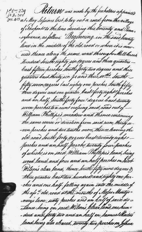
In 1804, in response to petitions for road improvements, the county authorized a survey to be taken for a new public road from Newport to the state line near Hockessin. It should be noted that this was not Newport Gap Pike (NGP), but predated it by several years. The path of the proposed road was generally similar to NGP, staying within about a half mile of the road we know today, but with several major differences. You can see from the image at the top of the post what Walt had to work with to map this thing out. There are two more equally thrilling pages that follow. Below is his map of the proposed road, and underneath that is a description of it in Walt's own words.
 |
| Proposed Public Road, 1804 |
The "Public Road" followed Wilmington Road from the state line to (now) Valley Road, then proposed a nearly straight path to Loveville Road (Robert Montgomery's tavern). It went down Loveville/McKennan's Church road to the current intersection with the Gap Newport Pike (the Priest's Gate), but then cut directly southeast to intersect with Duncan Road just below the house of Ephraim Yarnall, deceased.
As you can see, there are several interesting differences to note between this projected roadway and the one ultimately constructed about a decade later. First (going south to north), instead of heading straight out of Newport, the Public Road would have utilized existing roads for its southern portion. More importantly, it would have utilized Hersey's Bridge over Red Clay Creek, already in place in what would become Marshallton. It then followed what was the main road in the area, today's Duncan Road. This fits perfectly with what Walt told us in his earlier post, "Duncan Road: A Colonial Highway". We'll get to the red part in a moment.
The survey then has the road continue straight, veering from Duncan Road about where Faulkland Road meets it now. It continued straight until it met McKennans Church/Loveville Road, pretty much exactly where NGP intersects it today. The road then followed Loveville Road until its terminus at Old Wilmington Road, then shot in a straight line towards the northwest. It rejoined Old Wilmington Road at Valley Road, then followed Old Wilmington to the state line.
 |
| Section centering on the Faulkland Road/Duncan Road intersection |
Unfortunately for that story, the report writer was working under several erroneous assumptions. First, the 1804 survey was not for the Gap and Newport Turnpike, but for a possible public road. Second, the road plot did not, as we can see, completely follow existing roads, so there never was an old road east of the Yarnall House that it originally faced. The proposed road would have essentially cut through their backyard. Third, Yarnall House mentioned was not Holton Yarnall's Conestoga Wagon tavern, but was in fact the older home of his father, Ephraim Yarnall. This house sat on the southeast corner of Duncan Road and Faulkland Road, as shown in the diagram above. So much for the wrongway facing tavern.
But back to the road that never was. For the most part, had this road been built instead of the Newport Gap Pike we know today, things probably wouldn't have been a whole lot different. Two things do stand out to me, though. For one, it would have meant that this major roadway would have gone straight through the middle of what would become Marshallton. What effect would that have had on the always relatively small village? Would it have grow larger?
At the other end, the Public Road, following Old Wilmington Road, would have passed east of what became "downtown" Hockessin, which was centered around Lancaster Pike (as NGP is label up there). Would Hockessin still have grown where it is? Would it be centered along Old Wilmington Road, maybe near the Friends Meeting House? I don't know, but sometimes playing with alternate history can be fun -- even when it's just The Road That Never Was.
No comments:
Post a Comment