 |
| The "Irish Wall" |
In a prior post, we discussed Con Hollohan and his property known as Cuba Rock. According to his descendant Charles Esling, his home was the center of Roman Catholic worship until 1772. The northern portion of his tract became Mount Cuba. Con settled the land about 1747, and his estate sold the property to Evan Phillips in 1793. It’s reasonable to assume that Phillips took over Con’s home.
Based on research done in 1986, we made the circumstantial
case that Con’s homestead was in the very southwest corner of his property. Part of that evidence was a stone wall that still
stands today. I’ve now had the
opportunity to visit that wall and do some additional land research, and would
like to share the results.
The 1849 atlas of Rea & Price shows two homesteads on what had been Con’s tract – C. [Charles] Vanblunk at the southern end, and M. [Matthew] Kettlewood on Mount Cuba. A clever reader could ask, how do we know Con didn’t settle the Mount Cuba site? So I had to find evidence from when Con’s tract was split in two.
Evan and Mary [Harlan] Phillips “of Mill Creek Hundred” sold
the southern 30 acres to John V. Weber (later Weaver) in 1800. Then, in 1804, Evan Phillips “of Kennet
Township” sold the remaining 130 acres to Simon Johnson. This is consistent with the story of Mary and
Evan given in a Harlan family history, whereby they migrated to Bedford County,
PA by 1806. It tells me the first
property sold (the southern 30 acres) was Evan Phillips’ homestead (and by
extension, Con’s) since he moved away at that time. He was no longer in the area when the
northern tract was sold. The farm on
Mount Cuba was not established until the arrival of Simon Johnson after 1804.
So we can make a very good case that ties Con to the Vanblunk
property and the location of the wall, but can we connect the wall itself to
Con Hollohan? That seems to be the last
and most intriguing question.
The wall was one of five sites studied in 1986, when Ramsey Ridge was about to be developed as a subdivision. There are several records of this study, discussed in the prior post. But there are no definitive maps or photographs available, and there are gaps in the records. For example, a foundation is noted as Con Hollohan’s house, but its exact location is not given. Meanwhile, the bulldozers did their work and the wall seems to be the only artifact left standing. Thanks to the state archaeologist’s office though, we have this sketch of outbuildings at the corner of Con’s property, known as N-12088. (North is towards the upper right corner.)

The property owner graciously allowed me to visit the wall
in the company of two longtime residents (thanks Ken and Joe). It seemed obvious that the wall was part of the
bank barn identified in the sketch above.
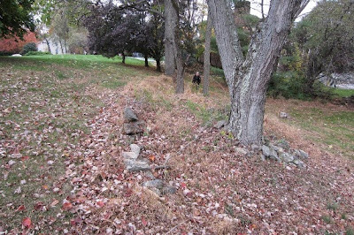
It was bigger than I imagined, probably 40’ x 30’. There is evidence of all four outer walls,
but no sign of interior walls or columns necessary to support a barn. In the photo below, you can see the north wall
to the right, and the bank wall to the left.

Next is a better picture of the bank wall, now
collapsed. Entry to the lower level was
from the east (near) or west (far) end.

The wall is part of a foundation, two-faced and using a very
coarse mortar. It is a rubble masonry
style using stones of many sizes, all unfinished and not laid in courses. This is an early style of
masonry that was used well into the 19th
century. Unfortunately, the outer face
of the wall is collapsing. It may not
last much longer.

As for the other structures noted in the archaeologist’s
sketch, we found a short row of stones where the open shed would have been, but
nothing as substantial as a foundation.
However, here is a photo looking north from the bank barn. If you follow that direction on the sketch,
it points to a stone cistern by the ravine (creek).

Hidden by the wall above, and about 50 yards
away, there is a depression in the yard.
It is about 8 feet in diameter, and 12-18 inches deep. It could be sunken earth over a pit of
construction debris, but it is exactly where the cistern should be. I don’t think that is a coincidence. The photo below also gives a clear sense of
the ravine (a small creek) below the site.

I think we can make a solid case that this location was Con
Hollohan’s homestead. There is no
evidence of an alternative site. The
location has a nearby stream and has access to Old Wilmington Road on a fairly
level path – important qualities for a good homestead frequently visited by
Jesuit travelers. A date stone with his
initials would be conclusive, but the circumstantial evidence is strong, and
prior researchers were led to the same conclusion.
The inventory of Con’s estate in 1788 mentions a stable with
loft, but that term is synonymous with barn – a place to shelter animals and
store hay/grain. (No John Deere tractors
to worry about back then.) The inventory
also tallies farm implements, four horses, eight sheep, and 13 head of other
livestock. They had to be sheltered
somewhere.
The masonry is of a very early style, comparable to his son
John’s bank barn built nearby in the 1780’s.
It is reasonable to conclude that Con built a stone stable with a
second-story loft, even if it was a simpler structure than we might expect
today. The barn was abandoned between 1900
and 1935, which suggests it was in disrepair by that time.
I can understand that there is no real basis to tie these
ruins to an “Irish Colony” from the 1680’s.
But lacking clear evidence to the contrary, if this was Con’s homestead,
then it was his barn. That means the
wall is about 250 years old and worthy of our recognition as a historical site,
built by a pious Irishman who served his church community for many years.
No comments:
Post a Comment