 |
| Peoples House and Barn (courtesy Dick Joyce) |
We'll take a look at all three properties eventually, but we'll start with the one that sat closest to Newport Gap Pike -- the Peoples farm. No, this wasn't some sort of Hippie commune (not that there's anything wrong with that). It was owned for over 150 years by the Peoples family, from 1854 until 1995. The main part of the former farm is now occupied by the neighborhood of Wyndom. Although of course the history of the land goes back further than 1854, we'll start with the Peoples family, since I know there are folks around who still remember them.
Their introduction into the story of Mill Creek Hundred took place on April 10, 1854, when William Peoples (1811-1868) purchased a little more than 64 acres of land from William Strode (we'll get back to Strode in a bit). William Peoples was born in Ireland, the son of Hugh and Mary Peoples. Although his father later resided (and died) in Tyler County, (West) Virginia, since several other of his siblings lived in Delaware I would assume the family came here first. At some point prior to 1838, William met and married Mary Ann Morrison. The couple lived in Wilmington, eventually increasing their family to include six children. The 1850 Census listed William as a carter, which meant that he drove a cart (two-wheeled as opposed to a four-wheeled wagon).
Whatever it was he was carting around in the city, by the early 1850's the now middle-aged William must have been looking towards a more rural existence. As previously mentioned, he bought his farm along the Newport and Gap Turnpike in 1854. But why that particular farm, in that particular area? What I've come to learn in doing this research is that much like in life itself, there is almost always a logical explanation for everything. It seems that this was not just a random place for Peoples to move his family. As it turns out, Mary Ann Morrison Peoples' father, Robert Morrison, had purchased the former Fr. Patrick Kenney farm on Lancaster Pike in 1833. That made him a neighbor to the larger tract of which William's 64 acres was once part. Although Robert had died several years before, the family would have been quite familiar with the area.
 |
| Boundaries of William Peoples' 64+ Acre Farm |
In one of those phenomenon that always pleases me, the boundaries of William's farm are still very evident on the map today. The illustration above shows where his tract fits on today's map. As we'll see shortly, this was about half of an earlier tract, being the portion to the west of the turnpike. Portions of the 64 acres were sold off over the years, but the bulk of the part north of Graves Road was still owned by William Peoples' descendants in the 1990's.
After William's death in 1868, possession of the farm eventually passed to his son William T. Peoples (1850-1919), but not without some formalities first. The elder William's will apparently dictated that the estate be sold at public auction. So, in November 1877 the farm was, in fact, sold -- to William T. for $7020 (so much for the friends and family discount). [Side note: The Robert S. Smith listed as an executor in the notice below is the husband of William's daughter Mary. He was an apprentice to William in his carting business, and took it over when William moved out of the city.] William T. and wife Laura raised five kids in their house on Graves Road, before moving to a house in the Cedars in 1912. (Actually, technically the house was in Hilltop, on the west side of Newport Gap Pike across from the Cedars.)
 |
| From the (Wilmington) Daily Gazette, October 24, 1877 |
The farm passed next to to William T. Peoples' oldest son, William Morrison Peoples (1891-1946). William M. married Florence Hobson in 1912. The couple had three children -- Eleanor, William Alfred, and Dorothy. William Alfred ("Al") was the last of the Peoples clan to work the family farm. Al eventually got out of farming, although the family held on to a portion of the property until the 1990's. Although the Peoples family lived on the farm for almost a century and a half, the property saw four different owners in the decade prior.
Recall that William Peoples bought his farm in 1854 from William Strode. Strode (a Philadelphian who had previously resided in Wilmington) purchased the farm four years earlier from Lewis Curlett, who had bought from Jacob Bowman in 1848. However, it's Bowman who appears on the 1849 Rea & Price map. (Yeah, sometimes they weren't completely up to date.) And even though he's "immortalized" on the 1849 map, Jacob Bowman only owned the farm for about 15 months. But when you get back before Bowman, things start to get more interesting. Yes, I know I'm using a very broad definition of "interesting".
As with William Strode, Jacob Bowman almost certainly never lived on the 64 acre tract. He was listed as being "of Lancaster County" when he purchased and as a Wilmingtonian when he sold. He may even have been sick, as he died not long after, in July 1849. The previous owner also likely used it as a rental farm, but unlike Bowman, he was a native of Mill Creek Hundred with deep roots here.
In May 1832, the administrators of John Mendenhall's estate attempted to collect a debt owed him by John Ford (more about Ford in a moment). To satisfy the debt, Sheriff Marcus E. Capelle sold Ford's 64 acre farm at auction to Justa Justis. Justis hailed from an old Swedish family, was a builder whose credits included the original Brandywine Springs Hotel, and resided in a still-extant house near Duncan and Milltown Roads. He would have bought Ford's farm to lease to tenant farmers, although he didn't do it for very long. Justa Justis died in 1836, leaving the farm to his wife Catherine. It was actually from Catherine Justis that Jacob Bowman purchased in 1847.
 |
| Original extent of Frederick Ford's tract. West portion to son John, east to son Frederick |
The ownership of the Ford family was an important time for the farm along Newport Gap Pike. For one thing, the turnpike didn't even exist yet when Frederick Ford bought his tract in 1798. The Great Road through the area was what's now McKennans Church Road/Loveville Road. Secondly, Frederick Ford didn't buy the 64 acres we've been discussing so far, but instead purchased a tad over 124 acres (as seen above). Looks like he may have inherited the money for it from his father (also Frederick), who owned a farm on Limestone Road where the development of Wood Creek is today. When the younger Frederick died about 1823, his will stipulated that his land be amicably divided between his sons Frederick and John. By this time the turnpike did exist, and neatly divided the property almost equally. Frederick took the eastern portion while John took the west side. This was officially done by indenture on April 3, 1825.
Taking the history of the property back further than the Fords starts to get a bit tricky. Ford bought the land from William Cannon (or Cannan), executor of his father Joseph Cannan's estate. Joseph Cannan died in 1793, but I've been so far unable to find when he purchased the tract. However, in 1767 James Mercer purchased 107 acres from Uriah Blue, which I believe was more or less the same tract. (Sometimes the area changes when it's resurveyed, or Mercer may have added a few acres here and there.) Information on Blue is scarce, but he may have been the husband of Mary Jordan, who may have been related to the James Jordan who owned a neighboring tract. What, if anything, is the relationship between them all and their lands is not clear.
 |
| Side and rear of the Peoples House, 1965 |
 |
| Peoples barn, looking east along Graves Road, 1956 |
As for the house itself, it's hard to be sure of its age since it was torn down about 20 or 25 years ago. We don't even have any good images of it, except from the Joyce family. Above is a close-up of the house taken from across a snowy field in 1965, and a view of the barn (looking west) from 1956. The house and barn faced Graves Road, which would be to the right. Below is a beautiful painting of the house and barn done from a photograph in 1979, by Kathleen Joyce Lofstedt, Dick's sister. (If they come across the original photo, I'll post that, too.) Since the house is certainly 19th Century, I have two possible guesses as to when it was built.
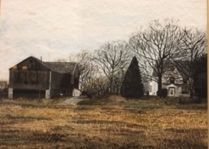 |
| Peoples House and Barn, by Kathleen Joyce Lofstedt (1979) |
Since the original, larger Ford tract was bounded on the east by The Great Road (now Loveville Road), it makes sense that their house would have been close to it. When John Ford took possesion of the western portion, he may have built the house for himself then. The other possibility is that Ford had built a smaller house originally. As we saw, after Ford's ownership the farm went through several short-term and absentee owners. Perhaps when William Peoples moved in (or maybe when William T. took over) he built a larger home for his family. Although we can't see much from the images, it is clear that there is an addition on the back and several Victorian Era features (pointed gable in the front and bay on the side). These were certainly added by the Peoples family. The barn, which was torn down in 1981 (the photo below, also from Dick Joyce, was taken soon after), is quite likely from the Ford era.

In any case, you can see that this now-unassuming area has a deep and rich past. Just the fact that it stayed in one family for over 150 years is impressive enough. Then we see that it had a pretty active previous 100 years. I think this farm is another great example of the idea that just about everywhere in Mill Creek Hundred has its own story, if only you know where to look.
Love this article! Thank you for all your research! Have you ever noticed a piece of ancient-looking stone wall on Loveville Road, across from Westgate Farms? It is best noticed this time of year when the foliage is dead.
ReplyDeleteI was not aware of that before. However, in looking at the old aerial pictures (see comment below), there was what appears to be a house and barn on the west side of Loveville Road, just south of Wembley Road. It doesn't appear on any of the 19th Century maps, but it does look like there's a dot there on the 1904 topographic map. The aerials show it there in 1968 but gone by 1982. My guess is that the wall is from one of those structures. I'm not sure who owned the property back then, but it looks like it would have been a part of the original, larger Ford tract.
DeleteInteresting article! Always fascinated with the past of this area. Not sure if you have ever used the site, but I use Historic Aerials website for some background research before I metal detect a spot I have permission on. It has aerials back to 1937 and topographicals sometimes into the 1800's. Good to use for precise building locations or general info. Shame they dug this place up (probably graded it) and built over top of it, doubt I would get permissions out there. Thanks for the history lesson!!
ReplyDeleteThanks, Eric. I use the Historic Aerials site a lot, including for this post and the comment above. Sometimes I lose half an afternoon to it.
DeleteHi Eric:
ReplyDeleteThanks for the link to Historic Aerials. But you are right. If you look at a recent image of the Graves Road area, the location which was once the Peoples Barn and house is now occupied by a couple of houses in the new subdivision. I drove by there a couple of years ago when I was back in Delaware for a high school reunion and it was sort of depressing.
Dick Joyce
I loved reading this article and getting a little more history about my family. Florence Hobson (Peoples) was my great Aunt. I have some more recent photos of the house before it was destroyed. If you would be interested in them, I can post them. Thank you for sharing this article.
ReplyDeleteYes, I'd love to see them!!! If you'd like, you can email them to me at mchhistory@verizon.net. I'd be thrilled to post them for you. Thanks!!!!
DeleteI have wonderful memories of your great aunt Florence Peoples. When my sister and I wandered next door, she would always invite us in to visit. I was pleased to read that she lived to be over 100 years old.
ReplyDeleteDick Joyce
Great article. Uriah Blue came from Somerset County, NJ. and migrates west with his family, wife, children, parents and siblings. If you want more info, I can provide it
ReplyDelete