 |
| Meeting House Road area today |
Over the course of the centuries, it's not unusual for roads to come and go, or for them to change in some way through the years. On the back of
the recent post about Benge Road, a question was raised about Meeting House Road, and about Lee Road, which looks like an extension of it north of Auburn Mill Road. When I started looking closer at the old maps of the area, I saw an interesting evolution of the roads in this area, north of Hockessin.
We'll start with the current configuration, seen to the right, and then go back and see the progression through time. As you can see, today Meeting House Road runs up from Old Wilmington Road to Auburn Mill Road, then Lee Road extends as a residential road up to about the state line. Auburn Mill Road comes west from Benge, goes past Meeting House for a short bit, curves north, then sort of peters out.
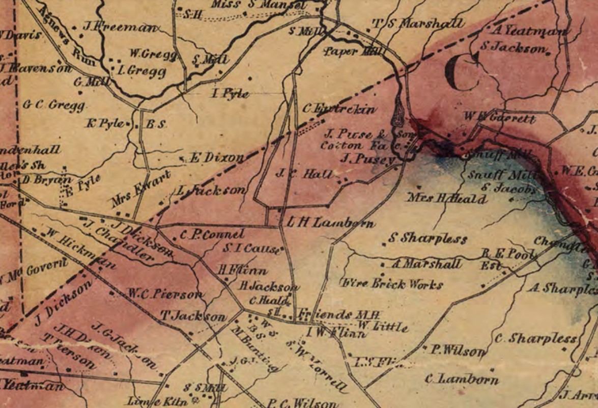
The two oldest maps we have - Heald's 1820 map and the 1849 Rea & Price - are basically identical to each other in their layouts. (There actually are a few older, Revolutionary War era maps that show roads, but they're not particularly precise and were drawn by people literally passing through the area, so not real helpful to us here.) They both show the Old Public Road (now Old Public Road and Benge Road at the north end) heading to the northeast and Old Wilmington Road continuing to the northwest. Meeting House Road is shown heading north from the Hockessin Friends Meeting House up into Pennsylvania. This makes clear the road's original purpose, which was as a pathway to the Marshall Mill on Red Clay Creek. Although much of this length is long gone, if you look again at the current map above you can see the original end of the road, now part of Marshallvale Lane.
 |
| The area in 1820 |
 |
| The area in 1849 |
Our next look comes eleven years later with the 1860 Philadelphia Region Map, and there are several new additions. For one thing, running west from Meeting House Road to Old Wilmington Road we see what's now the western end of Benge Road. The other major addition is the appearance of Auburn Mill Road, coming basically southwest from Red Clay Creek, then westerly (crossing Meeting House), then looping up to the north to intersect with Meeting House Road again, in Pennsylvania. There is also a short connector road between Benge and Auburn Mill, just west of Meeting House and Levis Lamborn's property. If it seems to you like there are some redundant roadways here, you're not alone.
 |
| The area in 1860 |
When we next see the area, a mere eight years later with the 1868 Beers map, several of those redundancies have been removed. Although Yorklyn Road has been added over east of Old Public Road, much of Meeting House Road is now gone, essentially ending at today's Benge Road. The segment between Benge and Auburn Mill Roads is shown as a dotted line, meaning it had become a private driveway or lane, no longer a public road. It was replaced by that newer stretch just to the west. And above Auburn Mill Road, the old Meeting House Road was now completely gone, replaced by the newer roadway. Although we can't see it here, the road still continued up to the Marshall's Upper Mill. This same configuration would remain in place, unchanged on both the 1881 and 1893 maps.
 |
The area in 1868
|
As we move into the 20th Century we move to the USGS topographic maps, beginning with the 1904 edition. It still looks pretty much the same, except that the eastern segment of Benge Road, detailed in the previous post, is now present. Also, the older segment of Meeting House Road between Benge and Auburn Mill Roads is again shown as a "real" road. And we can again see that the road does, indeed, extend all the way up to Marshall Bridge Road.
 |
| The area in 1904 |
Moving through the rest of the first half of the 20th Century, the topographic maps remain the same. However, in comparing them to some of the aerial photos from the 1930's and 1950's, I feel like the roads on the topographic maps maybe just weren't updated for a while. For instance, while the maps show the two sides of the square between Benge and Auburn Mill Roads as both being equal roads, in the photographs the eastern one (Meeting House Road) looks much more like a real road. And sure enough, by the next different-looking map in 1956, the western side is gone, and Meeting House Road runs all the way to Auburn Mill Road. Also, Auburn Mill Road stopped connecting up to Marshall Bridge Road long before it was removed from the map.
 |
| The area in 1937 |
The final piece of the puzzle comes in the early 1960's, with the construction of the new development of Auburn, located on the north side of Auburn Mill Road. Maybe for convenience, maybe because there was already an old roadbed there, or maybe because it was on the edge of the property, when Lee Road was laid out it was placed almost exactly where the original road was, gone for 100 years. It now extends up to about the state line.
While we all are constantly reminded of changes in roads today -- whether it be repaving, new roads, bypasses, widenings, or realignments -- it's easy to forget that changes happened in the past, too. Most major roads have remained relatively constant over the last 150 years (which makes reading the old maps much easier), but as we've seen here, some have come and gone. And this small section of Hockessin has see more than its share of changes to its map.


I just read your article about how Hockessin got its name in Hockessin Living and, while I appreciate the research, I have to respectfully disagree with your contention that it is not an old Indian word nor that it is related to one.
ReplyDeleteYou dismissed the possibility that the original term referred to either oak bark or foxes by pointing out that it couldn't be both. This is a logical fallacy. It certainly could be one or the other; our failure to remember which does not disqualify both.
As you note, the correct pronunciation places the accept on the penultimate syllable. That is consistent with dozens of place names throughout our region. You can find many examples in Philadelphia: Kingsessing, Moyamensing, Shackamaxon, Wissahickon. HoKESSin fits snugly within this list.
What you, and Mr. Weslager before you, failed to address is why William Cox would choose a non-existent word for the name of his house. Yes, people named their homes (some still do), but they weren't in the habit of simply making up nonsense words for the purpose.
So where did it come from? Use Occam's Razor. The most logical explanation is that the word was already in use for the area, and, given that the name does align with one or the other native word along with the suffix English speakers render as -en or -on or -ing, we have a language in which it is not a nonsense word.
In summation, while Mr. Cox's house probably did give its name to the area, that doesn't obviate the strong possibility that he took that name from an Indian word.
Al Mascitti
Hockessin
Al – I’m glad you saw the article, and I’m more than happy to continue the conversation. I’m sure you’ve thought about this and talked to more people about this (and everything else under the sun) over the years than I have, but I’ll do my best. To start with, I don’t think anyone knows the answer for sure, and we may never know. On the other hand, maybe someday a document will turn up that makes us all go, “Wow, of course that’s the answer!” In the meantime, the best we can do is follow the evidence and make our best guesses. That’s all this is for me, which I hope I’ve made clear.
DeleteThat being said, my wording might not have been clear, but I didn’t mean to say that because both can’t be true, neither can be true. The problem wasn’t that there were two theories, the problem is that there doesn’t seem to be any evidence to back them up. On this I’m leaning heavily on Weslager’s research, but the guy wrote several books on the local Native Americans and on their languages. The “Indian Name Theory” doesn’t seem to have popped up until the 19th Century, with no mention of it prior. There also seem to be linguistic issues, too. Here’s a link to the article he wrote in 1964. http://ans-names.pitt.edu/ans/article/view/453/452 I adapted my article from a blog post I wrote a few years back, but to fit it into the magazine I had to cut it down, which goes against my every inclination. Brevity may be the soul of wit, but it’s a pain in the ass when you’re trying to make a point and have lots of details. And tend to ramble.
You’re right that Hockessin does sound like many of the other natively-named places (btw, Shackamaxon is one of my favorite words), but that doesn’t make the theory correct. Using Occam’s Razor I would assume the sun goes around the earth, or that if someone is elected to a position they’re qualified for it. It’s a good place to start, but it doesn’t always get you to the right answer. And to get to the heart of your point, I think Cox did use a real word to name his estate. Again, this may not have been clear, but I think it was named Occasion (like an event), but with an 18th Century spelling, which was however you damn well wanted to spell it. (I’m guessing spelling bees were not really a thing then, or they were really easy.)
The bottom line is that this is still an open question, with several reasonable theories. My opinion happens to be that this is the most likely explanation. If hard evidence arises showing it was derived from a Leni Lenape word, I’d be thrilled to see it and have an answer. In the meantime, if people are thinking about and discussing historical things like this, I’m happy. Thanks for the comment!!!
Scott--Thanks for the reply, and the link to the original article.
DeleteThe "Occasion" theory is what planted the doubt in my mind. It's a relatively common English word, around since the 14th century.
While some words in English change pronunciation over time, such changes most commonly affect which syllable is stressed, as has happened with Hockessin in the modern era, when the stress switched from the second to the first syllable.
Voicing of vowels is probably the next-most-common area of change, as might occur with the long A of "occasion" shifting the soft E of "Hockessin." But for this to be the case, the penultimate consonant must also shift, from S to SH. That's a lot of change for something confined to what must have been a rather small geographical area.
While the wide variety of spellings Weslager lists isn't unusual for that time, it seems clear that all those spellings are trying to represent a word that's not pronounced like "occasion."
Like all historians, Mr. Weslager favors documentary evidence, as he should. I notice, though, that he acknowledges the possibility that the word could have existed previous to the Cox house. As you pointed out, we can't know for sure, which is what makes the speculating fun.
Something I should have said in my first comment: Your articles are great. Keep up the good work!
Al
I try to be an optimist where I can, so I'm holding out hope that somewhere there's a document that clears this up, and that someday I'll find it (almost certainly while looking for something completely unrelated). If so, I will certainly share it with all. And thank you very much for the kind words.
DeleteCan you do a similar write up on Ramsey Road south of here? I grew up in Hockessin and my dad told me that sometime in the late 80s/early 90s (my parents moved to Hockessin in 1987) the road was torn up in between each end to change it from a cut-through that people would use to get to Wilmington for work, because the people who lived on Ramsey thought it was too small and didn't like the traffic. I've looked online and can't find any references. Any idea?
ReplyDeleteAfraid I don't have quite as much information about this, but I think I can verify at least part of the story. (And happy to help out a fellow harrier - I ran XC at Dickinson before your time, and even coached a couple years.) As best as I can tell, Ramsey Road did get gutted about 1986, the same time Ramsey Ridge was being built. Although I can't find anything the confirms it, I assume it was done at the same time. Best I could find was an article from Oct 1987, and the writer says that to get from Barley Mill Rd to Ramsey Ridge he had to go down Barley Mill to Rolling Road and up Lancaster Pike and Old Wilmington Road. That tells me the road was cut off by that time. The 1982 aerial looks like the road is still solid all the way, so I'm still going with about '86. As far as the reason, I'm not going to argue with your dad. If people were cutting through, I would assume it was from Barley Mill to Old Wilmington to get to Lancaster Pike. Makes sense to me that the new development wouldn't want that extra traffic, especially as Hockessin was growing. If I find anything more I'll let you know.
DeleteOne more thing to add, which doesn't necessarily contradict the rest. I heard from frequent commenter Delaware21 that when he moved to the area in 1983, the road was open and useful as a shortcut, but was "narrow and in pretty rough shape." He recalls it being closed sometime around 84 or 85. He heard years later that the roadbed had been washed out in storms, and since it was so narrow and little-used, DelDOT decided it was easier to close it than repair and upgrade it.
DeleteI just wonder if they knew the development was coming soon, and found it better to gut the road before it got any additional traffic. Hope this helps!
Justing see this nearly 2 years after being posted. For what's its worth I can verify that Ramsey road was used as a shortcut between Barely Mill Road and Old Wilmington road. I first discovered this shortcut before I could drive. I had a summer job on an estate off of Barely Mill road just past Mt. Cuba road. I lived in Hockessin near the PA line off of Lancaster pike. Rather than ride my bike all the way down Brackenville to Barely Mill it was much shorter to take Old Wilmington rd to Ramsey and cut through. Also Barely Mill had a long steep hill and being so narrow it is not a safe road for bikes. Then when I went to High School (AI duPont)I would take the same shortcut in my car. I graduated in 1983 and can tell you it was still there and was in the same rough shape it had always been. I recall it being mostly gravel.
ReplyDeleteThanks for the confirmation. I found this interesting because I've come across roads or parts of roads being abandoned in the 1800's and early 1900's, but not many from more recently. And something I would have never known of or thought about if Andy hadn't mentioned it.
Delete