If you appreciate the work done on this blog, please consider making a small donation. Thank you!

If you appreciate the work done on this blog, please consider making a small donation. Thank you!

Friday, May 16, 2014

The Delcastle Water Troughs

See Update at bottom...

In the last post about the early history of the Delcastle Golf Course property, I mentioned that in addition to the few historic sites there I was aware of, George Williamson had also brought up a few things I had not known about before. One of the most interesting is the existence of five stone water troughs, like the one seen here. Each one has a different year carved into it. The years are 1902, 1903, 1905, and 1912.

To the best of our knowledge, no one knows anything about these troughs, who made them, or why. The significance of the dates is a mystery. By my thinking, there are three possibilities for who made the troughs. If they were placed in or near the years carved on them, then the most likely suspects would be the Greggs, assuming they still owned the farm. If they did sell it in the interim between 1900 and 1915, then whoever that owner was could have made them. Finally, if the troughs were placed after the fact, and the dates commemorated something in the past, then the county could have commissioned them during the workhouse farm era.

Tuesday, May 13, 2014

The Wells-Gregg Farm, AKA The Delcastle Farm

Date stone in the ruins of the Delcastle barn
Several years ago I did a post about the Delcastle Farm, the farm manned by prisoners from the New Castle County Workhouse at Greenbank. It was located along McKennans Church Road on the site which has been home to the Delcastle Golf Course since soon after the farm's closing a little more than 40 years ago. Although I'd wager most people (aside from readers of this blog, of course) are unaware of the history there, signs of the past still abound at the site. Several of the buildings, including the clubhouse and barn, date back to the prison farm era. However, the history of the property (of course) didn't begin with the county's purchase of it about 1915.

In addition to the workhouse farm era buildings, there are a number of other structures dotting the golf course that date to an earlier, and in some cases much earlier, time. I had been aware of some of these for a while (thanks to Mark Julian a few years back), and I've always been interested in the earlier history of the property. Recently, though, I was emailed by Buddy Williamson, who is also curious about the subject, and he even turned me on to a few things I didn't know before. He asked if I knew any more about the older history of the farm and sent me the photo above. Well, funny story.

Thursday, May 1, 2014

The Newport-Gap Road That Never Was

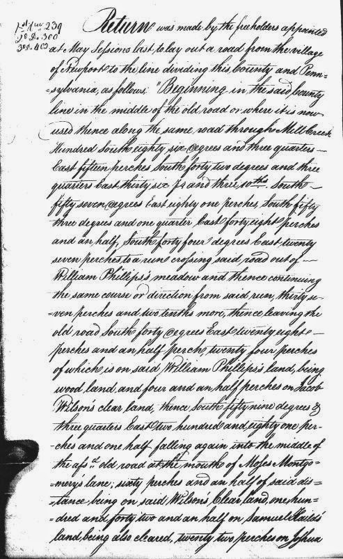
Page 1 of the 1804 Road Survey
As noted in several previous posts, the first few decades of the 19th Century were busy time of road building in the early Republic. The tumultuous years of the fight for independence and the somewhat chaotic period of sorting out the new country and its war-ravaged finances was drawing to a close. The country was growing, and so was its economy. With more people and merchandise on the move, everyone realized that the existing road system at the time was inadequate for the new nation. New thoroughfares needed to be constructed, whether by blazing new trails or improving old roads, many of which were no more than mildly glorified cow paths.

Then, as now, there were two different ways to go about funding something as ambitious as building a new road -- publicly or privately. In New Castle County, the task of publicly funding things like roads and bridges was given to the Levy Court. The newly-developed method of private funding for roads was the turnpike company, a corporation licensed by the state to build a road and allowed to collect tolls to pay for the maintenance of the road. As we've seen, the way history played out the Gap and Newport Turnpike Company was incorporated in 1808 in the State of Delaware, to extend southward a planned road leading from Gap, PA to the DE-PA state line. This is what we now call (in Delaware) Newport Gap Pike.

However, 210 years ago there was another plan floating around, prior to the forming of the turnpike company. And while it's obviously important to know what actually occurred in the past, it's also fun to think about the what ifs. The could have beens. The almosts. And to try to think how this alternate history would have differed from our own. In this case we're contemplating a road that never was, and thanks to the work of Walt Chiquoine, we can see exactly where this road would have been.

Tuesday, April 22, 2014

Mid-Week Historical Newsbreak -- McKennan-Klair House Sales Ad

So the other day I was looking through one of the collections of newspaper articles that Donna Peters had sent me a while back, trying to come up with something good to post this week. One in particular caught my eye, and after taking a closer look and checking a few things out I got very excited by what I found.

The ad, seen on the right, came from the July 26, 1764 edition of Philadelphia's Pennsylvania Gazette. At first glance it looks like a pretty typical ad from the time for a property sale, this one being in Mill Creek Hundred. The wording of the ad makes it clear that it's an estate sale, and goes on to give a good description of the property, the structures present on it, and some of the other personal property to be sold at the same vendue, or public auction.

Friday, April 18, 2014

Kidnapped to Mill Creek Hundred -- The Amazing Tale of James Annesley

James Annesley, one-time MCH resident
This is a story that's been bouncing around for a while, one of those I just never had a chance to get to before. It's been brought to my attention several times -- by Walt Chiquoine a while back, more recently by commenter Sue V., and probably at least once before that. I think one of the reasons I've put it off is that I've been waiting to find that one piece of solid evidence that ties it to the familiar for us, but I've yet to come across it. At this point accepted that our best bet is to put it out there and let more people take a look.

Many of you may be familiar with the 1886 Robert Louis Stevenson novel Kidnapped, which has been adapted for movies and television at least a dozen times over the past century. It's the story of a young Irish boy, recently orphaned, who discovers he's heir to an estate. Before he can take possession of the estate his evil uncle has him kidnapped to be sent off into servitude in the Americas. The boy escapes after his ship wrecks off the coast of Scotland, has a series of adventures across the Highlands, and eventually gets his inheritance back from his uncle. Stevenson's "boy's novel" has, over the years, become much beloved by readers everywhere.

As thrilling as the story is, what's really amazing is that it may well be inspired by a true story. In real life the boy, also an Irish orphan set to inherit an estate, did actually get sent to the Americas as an indentured servant by his uncle. The most intriguing part of it for us, though, is that the boy in question, James Annesley, spent many of his servile years right here in Mill Creek Hundred.

Thursday, April 10, 2014

The Justis-Jones House

The Justis-Jones House
In the recent post about the McComb-Winchester House I teased about a link between its most prominent owner, Henry S. McComb, and Mill Creek Hundred. That link comes in the form of the house seen here, the Justis-Jones House. It's situated on the west side of Newport-Gap Pike, just south of and up the hill from Brandywine Springs. It's one of those houses that lots of people probably see and think, "Gee, that's got to be an old house," but know nothing about. Although not the most flashy of homes in the region, to me it has its own air of dignity. It also happens to be somewhat unusual for the area in two major respects.

First, unlike most of the remaining houses from the first half of the 19th Century, it was never the manor house of a large farm or estate, and was only ever briefly occupied by its owner for much of its first 60 or 70 years. The second difference is in what is known about it. Whereas it seems with most sites that we're digging to find a scrap here and there about any owners we can, much research was done into the ownership history of the Justis-Jones House. This is one of the last sites in MCH listed on the National Register of Historic Places that I've gotten to here on the blog. It's NRHP nomination form has an almost mind-numbing amount of information about the various owners of the house. Needless to say, I'll just do a brief overview of its history, hitting the major points. Later on I'll provide a link the the NRHP form if anyone wants the whole story.

Friday, April 4, 2014

Yet Another Spring Hill Brewery Update

Spring Hill Brewery (courtesy John Medkeff, Jr.)
Almost a year and a half ago I wrote the first post about the Spring Hill Brewery, which was located on the north side of Barley Mill Road, just east of Barley Mill's crossing of Red Clay Creek. For a full refresher I suggest going back to review the original post, but the short story is that it was a brewery run by the Biedermann family for about 30 years, from 1881 until the early 1910's. I was able to piece together a good part of the Spring Hill story, but a few holes still remained.

Since I never consider any topic ever "Closed", the discovery of a few more pieces of information prompted the first follow-up post several months later. Most of this post covered the August 1909 explosion at the Wooddale Quarry, which I thought had marked the end of the Spring Hill Brewery. Also included were bits of aerial photos from the 1930's that I speculated might be of the Biedermann property, or what was left of it by then. Still, though, there were three main questions that were not sufficiently answered, at least in my eyes. When did the brewery truly cease operation (and why)? Where exactly was it? And what did it look like? I'm very happy to say, that with a huge assist from a new friend and fantastic resource, I think I have pretty good answers to all these lingering questions.

Friday, March 28, 2014

The St. James Church Road Bridge

SJCR, looping north and west past the church, 1881
Sorry this is a bit longer than normal, but I wanted to write everything up.

As some of you may recall from recent comments, a few weeks ago I went on a very nice walk in the woods with two guys who both had personal connections (unbeknownst to each other until we started walking and talking) to the area in question -- Bill Saadeh and Bill Harris. We met along the short stretch of Old Milltown Road behind the Harlan-Chandler Mill, just west of Limestone Road and south of Milltown. While I believe it's still technically a public road, it's really now a de facto private drive for the several houses along it. While we were standing there getting started one of the homeowners came out to see what these three men were doing standing around. We explained why we were there, and she was very nice and helpful (although I think the Bills' local connections helped ease any concerns she may have had).

We took a look at the old Harlan Mill (now apartments, I think), the old course of Milltown and Limestone Roads, and some of the old water features of the area. As we made our way south along Mill Creek, we found the old stone remains mentioned by Bill S. in one of his comments. There's not much there (in fact, you really have to look hard to see that it's man-made and not just an outcropping of rock), but we agreed that it probably was some sort of springhouse, quite possibly dating back to the Harlan Era (early 19th Century).