If you appreciate the work done on this blog, please consider making a small donation. Thank you!

If you appreciate the work done on this blog, please consider making a small donation. Thank you!

Wednesday, December 17, 2014

Red Clay Valley History Talk Series

I'm excited to announce here for the first time a new series of history-related events that I'm
personally really looking forward to -- The Red Clay Valley History Talk Series. The series is the brainchild of (among others) Tom Gears, who was looking for a way to promote and to educate people about the history of the area, especially the Red Clay Valley. After some intense negotiations (ok, I don't know how intense it was, but it does make it sound more dramatic, doesn't it?), the series of lectures was set up for three nights over the winter -- January 5, February 2, and March 2.

The talks will be held on Monday nights, beginning at 7:00 PM, at the new Wilmington & Western headquarters on Railroad Avenue in Marshallton. The subject of the first talk will be the New Castle County Workhouse at Greenbank, presented by Tom Gears, Raymond Harrington, and William Salerno. It should be a fascinating talk about a piece of history that I know many people still remember (only from the outside, I'm sure). Here is the "official" press release about the series:
A new series of talks focusing on the history of the Red Clay Valley will kick off on January 5, 2015. The talks will take place in the conference room at the Wilmington & Western Railroad headquarters, 1601 Railroad Ave., Wilmington, DE 19808. Thomas Gears, Raymond Harrington, and William Salerno will present the first talk, the New Castle County Workhouse at Greenbank at 7pm on January 5th. Next will be a talk on Mt. Cuba given by Elizabeth Fite from the Mt. Cuba Center on February 2nd. Scott Palmer, local historian and blogger who writes the popular Mill Creek Hundred Blog will present the History of Wooddale as the final talk on March 2nd. The series is an educational and community outreach project of Historic Red Clay Valley Inc.
Oh yeah, did I forget to mention that I'll be doing the final talk? Here's a link to the Facebook page set up for the series. I'll be putting up short reminder posts before each presentation, but feel free to check it out in the mean time. Hope to see you there!

Thursday, December 11, 2014

The Sons of Simon Cranston -- Part I

The Cranston-Klair House
In a recent post, we were introduced to Marcus Hook native and long-time Stanton area resident Simon Cranston. Even if Simon himself is not a well-known, household name in the area, his last name is. And although you can easily trace the reason for the family's success back to its patriarch, the more direct reason that the name lives on has more to do with the sons and grandsons of the old shipwright/farmer. During his lifetime, Simon Cranston became well-off enough financially that he was able to purchase several properties in and around the Stanton-Marshallton area, and at least one a bit further afield*.

While some of these properties were certainly money-making tenant farms, at least a few were purchased specifically to set up his sons in their own lives. And as was common in the area at the time, both his sons and daughters started those new lives with spouses from other land-owning families -- in several cases, from the same families.

Monday, December 1, 2014

Life and Blogging Update

For what it's worth, I wanted to take a moment and explain the recent lack of activity on my part here on the blog. About a week and a half ago the MCHHB family grew by 6lbs 15oz. (see unbelievably cute photo to right). Since that time, I've been pretty much offline (although almost always awake). Life is beginning to return to whatever will pass for normal for the near future, so my blogging will slowly, if somewhat sporadically for now, pick up. I do have a few things I want to get to, and I have a post that was nearly finished before "the incident". I'm now in the process of attempting to catch up on what I've missed, so to anyone who has commented or emailed me recently, I'll get back to you as soon as I can. Thank you for your patience -- we've still got lots of good stuff to get to!

Tuesday, November 11, 2014

Cuba Rock II -- The Irish Wall

The "Irish Wall"
-- Researched and Written by Walt Chiquoine

In a prior post, we discussed Con Hollohan and his property known as Cuba Rock.  According to his descendant Charles Esling, his home was the center of Roman Catholic worship until 1772.  The northern portion of his tract became Mount Cuba.  Con settled the land about 1747, and his estate sold the property to Evan Phillips in 1793.  It’s reasonable to assume that Phillips took over Con’s home.

Based on research done in 1986, we made the circumstantial case that Con’s homestead was in the very southwest corner of his property.  Part of that evidence was a stone wall that still stands today.  I’ve now had the opportunity to visit that wall and do some additional land research, and would like to share the results.

Wednesday, November 5, 2014

Simon Cranston

One phenomenon that has interested me since I began researching Mill Creek Hundred history is how certain families came to dominate particular areas, at least as far as owning property. It would usually begin with one settler on a homestead, who then would buy adjacent or nearby farms either directly for his sons or to increase his own holdings. Later on, the original properties would be divided and end up in the hands of multiple members of the family. This has happened over and over again, whether it was the Eastburns, Whitemans, Mitchells, Springers or numerous others. In the Marshallton and Stanton area, the dominant family for most of the 19th Century and well into the 20th was undoubtedly the Cranstons.

The Cranston name is of course still well known to area residents today, but their story, for the most part, is not. Besides in the name of a fire company, a neighborhood, and an apartment complex, the Cranston legacy also lives on in many of the houses they owned. Unfortunately, though, at least two have been (relatively) recently lost. Any telling of the Cranston story, however, has to begin with the first of the clan to settle in this area -- Simon Cranston.

Friday, October 31, 2014

Facebook Page Up and Running Again

I wanted to give a quick heads-up regarding the MCHHB's Facebook page. After more or less leaving it alone for a while, I've gotten back (hopefully permanently) to posting stuff there again. To be perfectly honest, I'm still trying to figure out exactly how to use it, as in what kind of things to put there. I'd like it to both support the blog and stand on its own.To that end, the recent posts are a mix of topics -- some related to the blog posts, some not. Today, for instance, I put a couple of 1965 aerial photos of the Prices Corner area on there.

If you're interested, you can find the page here. It's an open page (or whatever they call it), so you do not have to have a Facebook account to view it -- only to comment. I hope you enjoy it, and if anyone has any ideas about what kind of stuff I should put up there, let me know!

Wednesday, October 22, 2014

Mid-Week Historical Newsbreak: Century Old Fire Edition

The other day, with nothing better to do for a few minutes, I decided to travel back a century and check out what was going on in the area 100 years ago. I pulled up the local paper that Google has scanned in -- The Wilmington Sunday Morning Star -- and looked through the October 25, 1914 edition. There were several interesting articles, but this one stood out in particular due to the names of the people involved.

The article states that the day before (October 24, 1914), a fire had destroyed a barn on a farm between Stanton and Newport. The farm in question is referred to as "the Cranston farm", but was tenanted at the time by John W. Banks. If that name sounds vaguely familiar to regular readers, it's because John W. showed up in a post a while back about several Banks family artifacts. Specifically, he was connected to a ticket for a Thanksgiving Day (but not a Thanksgiving) party in 1884.

Although John had grown up in the Stanton area, by the time of the party he was living in Brandywine Hundred. As best as I could tell, he was leasing a farm somewhere near the Edgemoor/Bellefonte area. The 1900 Census finds him living at 206 Jefferson St. in Wilmington, with his brother William. John is listed as a carpenter, and with him is his wife Hannah and daughter Hattie. If I'm reading it correctly, Hattie is their only living child out of six.

Friday, October 17, 2014

How'd We End Up with a Funny Name Like Hockessin?

Of all the place names in Mill Creek Hundred, the one that invariably gives the most trouble to outsiders is the once-quiet, now upscale village of Hockessin. Any time I see a story relating to there popping up on a Philadelphia newscast, I sit waiting for the out-of-stater to pronounce it something that sounds like "hock a sin". As incorrect as that may be, the ironic thing is that almost all of us are probably actually saying it wrong. The reason hearkens back to the most probable origin of the name, a story that reaches back almost 300 years.

The problem is that this most likely origin of the name Hockessin is not the story most commonly told over the last century and a half. The other problem is that these alternative theories can be made to sound very plausible, giving them deep traction. Since the word "Hockessin" doesn't really sound like a name we're familiar with, or sound like any other English word for that matter, the natural reaction is to look to another language. In this region, that often means Native American languages.

Wednesday, October 8, 2014

Cuba Rock

Con Hollahan's mark
-- Researched and Written by Walt Chiquoine

This research began with some questions that Scott tossed out concerning Ramsey Ridge.  What did we know about Con Hollahan, Mount Cuba, and a reference to an “Irish Wall”?  Is Mount Cuba synonymous with Cuba Rock, the name Con gave to his land?  Where did the name Cuba come from?  And could an “Irish Wall” be a part of his original homestead?  We found sufficient evidence to re-tell the story of Con Hollahan and Cuba Rock in a new light.    

Con Hollahan is well-known in the historical writings of the Diocese of Wilmington, since he is credited with hosting the first Roman Catholic services in northern Delaware.  Con was described in a history of the local Catholic Church, written in 1884-86, by his descendant  Charles Esling.  From Esling’s history [which can be found here, beginning on page 117], we are told that Con Hollahan arrived from Ireland before 1747 and settled on a tract he called Cuba Rock.

Thursday, October 2, 2014

The Barkers of Barker's Bridge -- Part II

Samuel Barker's property and neighbors
(courtesy W. Chiquoine)
In the last post, we traced the history of the Barker family from the 1680's up until the late 1700's. We covered several generations and at least two distinct properties in the area that came to be called Barker's Bridge, along what became Lancaster Pike near what would later be known as Wooddale. We arrived at Samuel Barker (1721-1803), grandson (through Joseph) of the Samuel Barker who originally settled in the area. After mentioning seven of his nine children, we're left with the only two sons who didn't move out of the area -- William and Abraham. As noted, Samuel seems to have inherited his father Joseph's property along the Red Clay. This is corroborated by the fact that in 1762 Samuel filed a warrant for the 340 acre tract, and four years later had it resurveyed. It sounds like he was probably reaffirming his ownership of the tract, on which he would reside until his death in 1803. After his passing, the property was acquired by William and Abraham.

For some reason, when the rest of the Barker sons moved west to Pittsburgh, these two stayed behind. The histories specifically state that William never married, and there is no mention of a wife or children for Abraham, either. It is stated that William, like several of his brothers, served in the Revolutionary War, and fought at the Battle of Brandywine, among other places. It's not known (at least as far as I know) where any of the early Barker homes were located, or if any survived much longer than their residents. However, one house did outlast the family who built it, only to be lost not many years ago.

Monday, September 29, 2014

Mill Creek Hundred History on the Radio (sort of)

We take a short break from our regularly scheduled Part II post about the Barkers (which will be up in a day or two), for this special announcement. Have you ever sat and thought to yourself, "Self, I really like reading about Mill Creek Hundred history on this here blog, but you know what would be way more awesomer? If I could hear someone's mellifluous voice talking about Mill Creek Hundred history on my computer machine or other assorted electronic devices!" If so, you're in luck! (And you may want to try to get out more.)

I recently had the pleasure to be a guest on Delaware's Timeline, hosted by WDEL's Carl Suppa. The program has much the same mission statement as I do here, namely to get the word out about our fascinating and often overlooked local history. Carl was on the air at WDEL up until a few months ago, and hopes to have the program back on the air soon. In the meantime, he's continuing the show in the form of podcasts, which you can listen to over the internet.

My guest turn on the program is thanks largely to John Medkeff, who runs the awesomely fascinating site Delaware Beer History. He had been a guest back in the spring, and passed my name along to Carl. Long story short, Carl contacted me, and after coordinating our schedules I went into the studio a few weeks back to record the show.

We had an outline of what we wanted to cover, and I figured maybe we could stretch it out to an hour or so. Silly me. I think I was in there for almost three hours, much of that time spent talking history. I don't know how Carl ever got it all edited down, but he did. The podcast, all twelve parts, can be found here on WDEL's podcast page, just a little bit down on the left. You can also get there from the homepage by looking under "Features" along the top, then clicking on "Podcasts".

I had a great time recording the show, as anyone who's met me or read this blog knows, I love talking history. If you feel like listening in, check it out!

Thursday, September 25, 2014

The Barkers of Barker's Bridge -- Part I

The Barker House, c.1988
Over the nearly 350 years of Mill Creek Hundred history, many families have called the area home. Most clans currently within the MCH confines have arrived only within the last 60 years or so, mine included. But of course, some arrived much earlier. Of those older families, some had a major impact and then disappeared relatively quickly (like the Hadleys); some have been around for a long time, although maybe not prominent in MCH (like the Justis'); and some are just as visible as they were a couple hundred years ago (like the Eastburns). There's one family, though, that resided in and near MCH for over 150 years, then, with one notable exception, pretty much vanished from the area -- the Barkers.

The Barkers' history in Mill Creek Hundred may begin as early as the 1670's, in the early days of the English migration into the area. The patriarch of this branch of the family (there were several other closely related branches that sprang up in other areas) was Samuel Barker (1648-1720). Samuel hailed from Shropshire, England, in the west midlands near Wales. Exactly when he sailed for the New World seems to be in doubt, but one account has him making a petition for a parcel land before the court in New Castle in 1677. Scharf notes that he bought in 1680 and sold in 1682 land near Stanton. What seems to be more certain is that in March 1685, Samuel Barker was granted 200 acres of land in Christiana Hundred by the newly-arrived William Penn. This was before Mill Creek Hundred was created out of Christiana Hundred, so the parcel along Red Clay Creek was actually mostly in what would later be MCH.

Tuesday, August 19, 2014

Dr. Lewis Heisler Ball

Sen. L. Heisler Ball, 1919
As has been noted several times in the past, Mill Creek Hundred doesn't really boast much in the way of nationally famous sons or daughters. No Presidents, Nobel Prize winners, or world-famous artists hailed from here, as far as I know. That doesn't mean, however, that there weren't certain people who had their time upon the statewide or national stage. One such person who did rise above his humble beginnings was the son of a well-entrenched local family -- the physician turned politician Lewis Heisler Ball.

L. Heisler Ball (as he was more often known) was born in Milltown on September 21, 1861, the son of John and Sarah (Baldwin) Ball. Sarah Ball (1834-1905) was the daughter of William Baldwin, and probably grew up on Polly Drummond Hill Road, just south of Ebenezer Methodist Church. John Ball (1828-1900), Heisler's father, was the son of John Ball, Sr., and both Johns have popped up several times before in other posts. Both John Balls grew up near Milltown, in what I've dubbed the Joseph Ball House, still standing in what is now the parking lot of the Arundel Apartments.

Thursday, August 14, 2014

More About Water Troughs!

Water Trough at Canby Park
No, when I started writing this blog I had no clue that one day I'd end up writing multiple posts about stone water troughs, but here we are. What started out as a side note discovered while investigating the early history of the Delcastle Farm has turned into an interesting little mystery. Now, new information has widened the scope of the story even further.

To briefly recap the story, go read the post. To slightly less briefly recap, there are five stone water troughs sitting in two locations at the Delcastle Golf Course -- formerly a prison farm associated with the New Castle County Workhouse at Greenbank -- on McKennans Church Road. The troughs have dates carved into them, ranging from 1902 to 1912. One has an M carved on the reverse side.

Tuesday, August 5, 2014

Ashland Mill -- Part 2

In the previous post, we began looking at the history of the Ashland Mill, located on the east (north?) or Christiana Hundred side of Red Clay Creek along Barley Mill Road. We saw how the original mill was constructed about 1715 by John Gregg, and remained in the family until 1797. During that time, two houses were built that still stand -- the circa 1720 stone house behind the mill site and the 1737 brick house across Creek Road on a slight rise.

The mill and both houses passed into the Philips family for the next half century or so, before being sold sometime in the early 1850's. It's probably at this point that the 1737 brick William Gregg House was separated from the mill property and the stone house. On the 1868 map, the two are shown under different ownership. We'll leave William's beautiful house now, and focus our attention on the mill property and a "newer" tract just to the west, in Mill Creek Hundred. This is because in 1862, the old Gregg Mill at Ashland was purchased by another longtime local resident, Jehu D. Sharpless.

Thursday, July 17, 2014

Ashland Mill -- Part 1

Ashland Mill, 1895
As we've seen many times on this blog, Mill Creek Hundred may be the most aptly named of all the hundreds in Delaware (although to be fair, I don't know how many ducks there are in Duck Creek Hundred, and I don't even want to deal with either of the Murderkills). And even though we've covered many of the mills in the area already, there are still some we've yet to hit upon. One point that has come up several times is the fact that the majority of the mills along Red Clay Creek are situated on the west (MCH) side of the waterway. There are a few, however, on the Christiana Hundred side, including one of the earliest, which has direct connections to "our side" of the creek. This one was even mentioned previously in an "On the Road" post.

The Gregg family originally settled in eastern Christiana Hundred in the 1680's, near what would later become Montchanin. William Gregg, the patriarch of the family, had four children, but the one we're concerned with now was his son John. John Gregg (1668-1738) was a prodigious purchaser of property, ending up with holdings in the thousands of acres. One of his purchases was a 200 acre tract straddling Red Clay Creek, which he bought from Letitia Penn's agent in 1702.

Wednesday, July 16, 2014

The Aaron F. Klair Bible

A couple of years ago I wrote a post about Aaron F. Klair and his family, spurred by an earlier post about the anti-liquor Klair Law. Then, not long ago, I got one of those wonderful, completely out of the blue emails I receive once in a while. It was from a woman named Marion who had purchased an old Bible off of Ebay a while back. What she enjoys doing is buying old books, diaries, Bibles, and so forth, and researching the people who owned them. In this case she ended up on the blog here because this particular Bible had once belonged to Aaron F. Klair.
 
As a quick refresher, Aaron Francis Klair was born in 1863 to Egbert and Elizabeth (Cranston) Klair, who at the time resided in the stone house now on the grounds of the former Three Little Bakers golf course. Aaron F.'s grandfather was also named Aaron, and his father was Frederick Klair. It was Frederick who, in 1810, moved his family from Pennsylvania into house on Limestone Road formerly owned by Rev. William McKennan.

Tuesday, July 8, 2014

Catching Up and Some Odds and Ends

Old Capitol Trail and Newport Gap Pike, 1965
As you may have noticed, the blogging here has been a bit light the past month. Ok, more than light. Non-existent. I apologize for the hiatus to anyone who looks forward to these posts, but my real life has been busy and hectic the past few weeks. Things are finally starting to calm down a bit now, and beginning to get back to whatever passes for normal these days. For whatever it's worth to whoever might care, I'm hoping to get back to a more regular posting schedule this week.

Now that that's out of the way, I have a few little things that, for lack of a better idea, I'm just going to throw all together in one post here:

Tuesday, June 10, 2014

Mid-Week Historical Newsbreak -- Another Mill Bites the Dust

(Philadelphia) Times - August 16, 1891
I haven't gotten to one of these newsbreaks in a while, so here's a quick little story. It comes to us from The Times of Philadelphia, dated August 16, 1891. It tells of the fire that destroyed Joseph Derrickson's woolen mill, reportedly near Stanton. As best as I can determine by looking at the maps, this is referring to the former Spring Grove Mill located on Mill Creek just below Stoney Batter Road.

The 1881 and 1893 maps both label the mill as "A. Derrickson", presumably for Aquila. This is slightly problematic in that Aquila Derickson passed away in November 1881. The Joseph mentioned in the article was Aquila's eldest son, who it seems acquired the mill after his father's death. I think the 1893 mapmakers may have leaned heavily on the 1881 version, since I recall seeing other instances where the later map seemed like it was not updated.

The Derickson Mill in 1881

For a while now I've wanted to write a post about this mill, but I've been unable to come up with much of what you'd call "facts", or "actual information". The closest I've come recently was discovering that Samuel Broadbent, the son of the former mill owner James Broadbent, seems to have built the Marshallton home of our new blog friend Craig. Beyond that it gets a bit thin.

I'm still hopeful that someday I'll stumble upon...um, I mean gallantly discover, more about this mill. If nothing else this article gives us an idea of the state of the mill in the early 1890's. My hunch is that it had already been shut down for good and was never rebuilt. If more comes up, I'll be sure to pass it along.

Thursday, May 22, 2014

The Knowles Family

Harry Knowles, brother of Cpt. Thomas Knowles
Aside from researching and writing these posts, there are a few little projects I've always wanted to do but have never had the time to get to. One of them was to go through the censuses (1850 and later) and look for odd and unusual occupations. Maybe even try to calculate how many people were engaged in something other than farming or mill/factory work. There will be a fair number of expected "others", things like carpenters, doctors, teachers, cobblers, coopers and the like. I also assume that there will be a few that I either have to look up or that will take me completely by surprise. This is the story of one of the later. Would you be surprised to know that in 1880, in Mill Creek Hundred, there lived a lighthouse keeper?

There was, and his name was William H. C. Knowles. He came from a family of sea men and probably only lived in MCH for a few years, but his family has an interesting story. I was turned on to the Knowles family a few weeks back by an email from a descendant of the family, Cindy Cunningham. She knew a little about this part of the family, and I did some research and came up with a little more. Our hope is that someday someone with even more information about the Knowles family will help fill in some of the gaps.

Friday, May 16, 2014

The Delcastle Water Troughs

See Update at bottom...

In the last post about the early history of the Delcastle Golf Course property, I mentioned that in addition to the few historic sites there I was aware of, George Williamson had also brought up a few things I had not known about before. One of the most interesting is the existence of five stone water troughs, like the one seen here. Each one has a different year carved into it. The years are 1902, 1903, 1905, and 1912.

To the best of our knowledge, no one knows anything about these troughs, who made them, or why. The significance of the dates is a mystery. By my thinking, there are three possibilities for who made the troughs. If they were placed in or near the years carved on them, then the most likely suspects would be the Greggs, assuming they still owned the farm. If they did sell it in the interim between 1900 and 1915, then whoever that owner was could have made them. Finally, if the troughs were placed after the fact, and the dates commemorated something in the past, then the county could have commissioned them during the workhouse farm era.

Tuesday, May 13, 2014

The Wells-Gregg Farm, AKA The Delcastle Farm

Date stone in the ruins of the Delcastle barn
Several years ago I did a post about the Delcastle Farm, the farm manned by prisoners from the New Castle County Workhouse at Greenbank. It was located along McKennans Church Road on the site which has been home to the Delcastle Golf Course since soon after the farm's closing a little more than 40 years ago. Although I'd wager most people (aside from readers of this blog, of course) are unaware of the history there, signs of the past still abound at the site. Several of the buildings, including the clubhouse and barn, date back to the prison farm era. However, the history of the property (of course) didn't begin with the county's purchase of it about 1915.

In addition to the workhouse farm era buildings, there are a number of other structures dotting the golf course that date to an earlier, and in some cases much earlier, time. I had been aware of some of these for a while (thanks to Mark Julian a few years back), and I've always been interested in the earlier history of the property. Recently, though, I was emailed by Buddy Williamson, who is also curious about the subject, and he even turned me on to a few things I didn't know before. He asked if I knew any more about the older history of the farm and sent me the photo above. Well, funny story.

Thursday, May 1, 2014

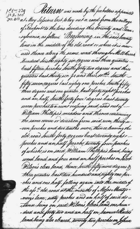
The Newport-Gap Road That Never Was

Page 1 of the 1804 Road Survey
As noted in several previous posts, the first few decades of the 19th Century were busy time of road building in the early Republic. The tumultuous years of the fight for independence and the somewhat chaotic period of sorting out the new country and its war-ravaged finances was drawing to a close. The country was growing, and so was its economy. With more people and merchandise on the move, everyone realized that the existing road system at the time was inadequate for the new nation. New thoroughfares needed to be constructed, whether by blazing new trails or improving old roads, many of which were no more than mildly glorified cow paths.

Then, as now, there were two different ways to go about funding something as ambitious as building a new road -- publicly or privately. In New Castle County, the task of publicly funding things like roads and bridges was given to the Levy Court. The newly-developed method of private funding for roads was the turnpike company, a corporation licensed by the state to build a road and allowed to collect tolls to pay for the maintenance of the road. As we've seen, the way history played out the Gap and Newport Turnpike Company was incorporated in 1808 in the State of Delaware, to extend southward a planned road leading from Gap, PA to the DE-PA state line. This is what we now call (in Delaware) Newport Gap Pike.

However, 210 years ago there was another plan floating around, prior to the forming of the turnpike company. And while it's obviously important to know what actually occurred in the past, it's also fun to think about the what ifs. The could have beens. The almosts. And to try to think how this alternate history would have differed from our own. In this case we're contemplating a road that never was, and thanks to the work of Walt Chiquoine, we can see exactly where this road would have been.

Tuesday, April 22, 2014

Mid-Week Historical Newsbreak -- McKennan-Klair House Sales Ad

So the other day I was looking through one of the collections of newspaper articles that Donna Peters had sent me a while back, trying to come up with something good to post this week. One in particular caught my eye, and after taking a closer look and checking a few things out I got very excited by what I found.

The ad, seen on the right, came from the July 26, 1764 edition of Philadelphia's Pennsylvania Gazette. At first glance it looks like a pretty typical ad from the time for a property sale, this one being in Mill Creek Hundred. The wording of the ad makes it clear that it's an estate sale, and goes on to give a good description of the property, the structures present on it, and some of the other personal property to be sold at the same vendue, or public auction.

Friday, April 18, 2014

Kidnapped to Mill Creek Hundred -- The Amazing Tale of James Annesley

James Annesley, one-time MCH resident
This is a story that's been bouncing around for a while, one of those I just never had a chance to get to before. It's been brought to my attention several times -- by Walt Chiquoine a while back, more recently by commenter Sue V., and probably at least once before that. I think one of the reasons I've put it off is that I've been waiting to find that one piece of solid evidence that ties it to the familiar for us, but I've yet to come across it. At this point accepted that our best bet is to put it out there and let more people take a look.

Many of you may be familiar with the 1886 Robert Louis Stevenson novel Kidnapped, which has been adapted for movies and television at least a dozen times over the past century. It's the story of a young Irish boy, recently orphaned, who discovers he's heir to an estate. Before he can take possession of the estate his evil uncle has him kidnapped to be sent off into servitude in the Americas. The boy escapes after his ship wrecks off the coast of Scotland, has a series of adventures across the Highlands, and eventually gets his inheritance back from his uncle. Stevenson's "boy's novel" has, over the years, become much beloved by readers everywhere.

As thrilling as the story is, what's really amazing is that it may well be inspired by a true story. In real life the boy, also an Irish orphan set to inherit an estate, did actually get sent to the Americas as an indentured servant by his uncle. The most intriguing part of it for us, though, is that the boy in question, James Annesley, spent many of his servile years right here in Mill Creek Hundred.

Thursday, April 10, 2014

The Justis-Jones House

The Justis-Jones House
In the recent post about the McComb-Winchester House I teased about a link between its most prominent owner, Henry S. McComb, and Mill Creek Hundred. That link comes in the form of the house seen here, the Justis-Jones House. It's situated on the west side of Newport-Gap Pike, just south of and up the hill from Brandywine Springs. It's one of those houses that lots of people probably see and think, "Gee, that's got to be an old house," but know nothing about. Although not the most flashy of homes in the region, to me it has its own air of dignity. It also happens to be somewhat unusual for the area in two major respects.

First, unlike most of the remaining houses from the first half of the 19th Century, it was never the manor house of a large farm or estate, and was only ever briefly occupied by its owner for much of its first 60 or 70 years. The second difference is in what is known about it. Whereas it seems with most sites that we're digging to find a scrap here and there about any owners we can, much research was done into the ownership history of the Justis-Jones House. This is one of the last sites in MCH listed on the National Register of Historic Places that I've gotten to here on the blog. It's NRHP nomination form has an almost mind-numbing amount of information about the various owners of the house. Needless to say, I'll just do a brief overview of its history, hitting the major points. Later on I'll provide a link the the NRHP form if anyone wants the whole story.

Friday, April 4, 2014

Yet Another Spring Hill Brewery Update

Spring Hill Brewery (courtesy John Medkeff, Jr.)
Almost a year and a half ago I wrote the first post about the Spring Hill Brewery, which was located on the north side of Barley Mill Road, just east of Barley Mill's crossing of Red Clay Creek. For a full refresher I suggest going back to review the original post, but the short story is that it was a brewery run by the Biedermann family for about 30 years, from 1881 until the early 1910's. I was able to piece together a good part of the Spring Hill story, but a few holes still remained.

Since I never consider any topic ever "Closed", the discovery of a few more pieces of information prompted the first follow-up post several months later. Most of this post covered the August 1909 explosion at the Wooddale Quarry, which I thought had marked the end of the Spring Hill Brewery. Also included were bits of aerial photos from the 1930's that I speculated might be of the Biedermann property, or what was left of it by then. Still, though, there were three main questions that were not sufficiently answered, at least in my eyes. When did the brewery truly cease operation (and why)? Where exactly was it? And what did it look like? I'm very happy to say, that with a huge assist from a new friend and fantastic resource, I think I have pretty good answers to all these lingering questions.

Friday, March 28, 2014

The St. James Church Road Bridge

SJCR, looping north and west past the church, 1881
Sorry this is a bit longer than normal, but I wanted to write everything up.

As some of you may recall from recent comments, a few weeks ago I went on a very nice walk in the woods with two guys who both had personal connections (unbeknownst to each other until we started walking and talking) to the area in question -- Bill Saadeh and Bill Harris. We met along the short stretch of Old Milltown Road behind the Harlan-Chandler Mill, just west of Limestone Road and south of Milltown. While I believe it's still technically a public road, it's really now a de facto private drive for the several houses along it. While we were standing there getting started one of the homeowners came out to see what these three men were doing standing around. We explained why we were there, and she was very nice and helpful (although I think the Bills' local connections helped ease any concerns she may have had).

We took a look at the old Harlan Mill (now apartments, I think), the old course of Milltown and Limestone Roads, and some of the old water features of the area. As we made our way south along Mill Creek, we found the old stone remains mentioned by Bill S. in one of his comments. There's not much there (in fact, you really have to look hard to see that it's man-made and not just an outcropping of rock), but we agreed that it probably was some sort of springhouse, quite possibly dating back to the Harlan Era (early 19th Century).

Wednesday, March 19, 2014

MCHHB on the Road -- The McComb-Winchester House

The McComb-Winchester Mansion
Since it's been a while since we've done this, I thought we'd take a trip beyond the borders of Mill Creek Hundred to visit one of my favorite of the lost houses of Wilmington. On the north side of Rodney Square today stands the Classical Revival building erected in the 1930's as a federal building, courthouse, and post office. In recent decades its public duties have gone elsewhere, and now it serves as the headquarters for Wilmington Trust, now a subsidiary of M&T bank.  But for about 20 years, this block bounded by 11th, 12th, Market, and King Streets was owned by one of the wealthiest men in the city - Henry S. McComb.

On the southwest corner of the block stood the site of the once majestic Henry S. McComb Mansion. The space that's now the west end of the old Federal Building was formerly home to one of the most impressive examples of early Victorian architecture in Wilmington. Built in the Second Empire style imported from France, the McComb Mansion displayed the style’s typical mansard roof and turrets. In addition to the front of the house facing Eleventh Street, there was an extensive wing along the Market Street side. Built of brick and rising to three stories, the house was as powerful as the man who built it.

Wednesday, March 12, 2014

Mid-Week Historical Newsbreak -- Merestone Sales Ad

Mixed in amongst the old newspaper clippings of fires, horrid deaths, animal abuses, train wrecks, and
murders (guess what -- there never was a "peaceful good old days") that have been forwarded to or found by me, there are also a fair number of real estate sales ads. Depending on how old they are and how good your knowledge of the area is, for many of them you can determine exactly where the property is that's for sale. If you can, the ad can be an invaluable resource, giving you a heaping portion of information about the property and what it consisted of at the time. The ad seen to the right is is an example of one whose identity was not all that difficult to discern.

The ad comes to us from Philadelphia's Public Ledger, dated December 16, 1844. It tells of the upcoming sale of 216 acres belonging to John M. Beeson of Mill Creek Hundred. The ad lists, among other things, a part stone and part frame mansion house, a 70 x 40 foot three story stone barn, wagon house, spring house, tenant house, corn crib, and other out-buildings. The property also had a "thriving young apple orchard" which also had pear trees, cherry trees, and other fruit. All in all sounds like a nice property, and one I should have written about. Turns out, I did!

Thursday, March 6, 2014

John Quill and the Craig-Quill House

A couple of years ago I wrote a post about the Walter Craig House, or at least what's left of it. I was taken to it by nearby resident Roger Suro, who had come across the ruins on some of his frequent hikes in the area. While today the house and barn are nothing more than a few low, ruined walls, for at least the better part of a century this now wooded locale was a thriving farm. In the post I was able to cobble together the framework of a story for the house, from its ownership by Walter Craig to its sale and ownership by John Quill. From census and map data I came up with a few general facts for each owner, but not really a whole lot, to be quite honest. Now, thanks to one of those beautiful out-of-the-blue emails I get from time to time, we have a bit more concrete information about the second owner of the house, John Quill, and his family.

The information comes to us from Chris Haugh, the great-great-grandson of the Irish immigrant Quill. Chris forwarded to me a very helpful heap of genealogical information about the Quill family, as well as three deed records that deal with John Quill and the land under and around his home. Oh, and some pictures, too. I do love old pictures.

Wednesday, February 19, 2014

Duncan Road: A Colonial Highway

As promised, here is the fourth and (for now) final post relating to the Conestoga Wagon, aka, the Yarnall Tavern. In the last post questioning the original opening date of the tavern, one argument I made for a post-1810 timeframe was the fact that the road that became the Newport and Gap Turnpike more or less didn't exist before then. Here now is Walt Chiquoine, who has much more to say on the topic.

By (now frequent) Contributor Walt Chiquoine --

The historical importance of roads is their role in commerce – getting products from here to there. The colonial roads through MCH needed to get local farm products to market, but more significantly, they allowed products from Lancaster and Chester Counties to reach the mills and wharves at Stanton, Newport, and Wilmington. This was as true of beaver pelts and tobacco in 1650 as it was of grain, dairy, and produce in 1750 and 1850.

Many historians attribute early roads to the pre-existing American Indian trails. While in many cases this is probably true, it is also a trap. No one has a 1637 map of the old Indian trails, so there is no hard evidence of those trails, only stories. Any road could be claimed to follow an Indian trail, and none of us would be the wiser.

Delaware Brewing History Lecture -- Tonight!

Sorry this is pretty last minute, but if anyone is looking for something to do tonight -- Wednesday, February 19, 2014 -- there will be a lecture that might be of interest. John Medkeff, Jr. will give a talk about a subject that he's done quite a bit of research on -- Brewing in Delaware. Yes, beer and history! Two great tastes that...oh, never mind. The lecture will take place at the New Castle Court House Museum in Old New Castle, and will begin at 7:00 PM. Admission is $5 (free for New Castle Historical Society members). More information about the NCHS can be found here, and for the Court House Museum, here. I'm going to try to make it down there (I don't even think there's any snow in the forecast for the next 12 hours!!!). If you don't have any plans, stop on by. I'm sure it will be a very interesting and informative talk.

Thursday, February 13, 2014

Mid-Week Historical Newsbreak -- Osage You Can See

Delaware State Reporter, Aug. 24, 1855
I realized it's been a while since we've had a Newsbreak wherein someone or something didn't perish in a fairly gruesome manner, so here's a story about plants. It comes from the August 24, 1855 issue of the Delaware State Reporter and has to do with a new type of plant introduced into Corner Ketch. It says that Samuel Loyd started growing osage orange trees about ten years earlier, and now has a nice grove and over a mile of hedge.

The Samuel Lloyd of the article ran the store at the corner of Corner Ketch Road and Doe Run Road, and was the first Postmaster of the Pleasant Hill (Corner Ketch) Post Office. The osage orange is a small tree/large shrub often used in hedges. It has a round, bumpy, green fruit roughly the size of a softball, sometimes called horse apples or monkey balls.

I no longer have the email in which Donna Peters originally sent me this story, but I think she said that this type of tree can still be found in and around Corner Ketch. If so, these trees are no doubt descendants of the originals planted by Lloyd in 1845. Something cool to think about the next time you drive through the area.

Tuesday, February 11, 2014

When Did the Yarnall Tavern Open?

I hope I'm not boring anyone with this, now the third post related to the Conestoga Wagon Inn, also known as the Yarnall Tavern. It was truly a minor establishment with a short lifespan, important more for what came after it (the Brandywine Springs Hotel and then the amusement park) than for its own sake. But one of my first gateways into local history was Brandywine Springs Amusement Park, so things related to it have a special place for me. This whole investigation was originally just supposed to be a quick mention of the mysterious second tavern, covered in the last post, which I only became aware of (and its connection to the Conestoga Wagon) recently. Then Walt Chiquoine had to go and do some great work piecing together the early history of the Yarnall family in MCH and of property ownership in the area, so I had no choice but to do a separate post covering that and the founding of the first tavern. (Just go with me on the "no choice" thing, OK.)

Then, while putting the pieces together for that, a few things seemed like they just didn't fit. After consulting with Walt again, I decided that the conventional wisdom about the Conestoga Wagon was almost certainly not correct. I don't mean to harp on this again, but if you'll recall there was very little if anything ever written about Holton Yarnall's tavern that didn't have to do with its final years, the sale of the property in 1827, and the coming of the big, new hotel. Just about the only thing ever said about Yarnall's establishment was that it was a "Colonial Era tavern". As we saw, just going by Holton Yarnall's birth year (1774) should tell you that he didn't run a tavern in the Colonial Era. But there were other things, too....

Wednesday, February 5, 2014

The Yarnalls (and More) and Another Inn

The Conestoga Wagon, or Yarnall Tavern
In the previous post, we looked at the early history of the Yarnall family, their acquisition of land around the area now known as Brandywine Springs, and the opening of the Conestoga Wagon inn, often called the Yarnall Tavern. In this post we'll take the story forward, focusing on the end of the Conestoga Wagon and on another "Mystery Inn" that may have been a successor to it.

As noted in the first post, it's unclear exactly when the Conestoga Wagon first opened. My hypothesis was that Sarah Yarnall began keeping the inn soon after her husband Ephraim's death in 1793. New information has called that theory into question, quite possibly moving the date of the house and tavern significantly forward. This new idea will be dealt with more fully in another post to come.

Wednesday, January 29, 2014

Mid-Week Historical Newsbreak -- Who's Got Your Tongue?

Two weeks ago in the Newsbreak story about the horse killed by bees, I promised an even more gruesome story to come. Well, here it is. This story comes from the Juniata Sentinel and Republican, dated January 02, 1878. It relates an incident where a horse owned by a Hockessin man became spooked by an oncoming train. The farm hand who was working with the horse tried to get it to come forward, for some reason, by grabbing its tongue. The horse was so scared that it continued to back off, not stopping until it had torn out its own tongue!

To answer your first question, no, I don't know why I would post something like this. I just had it is all. The second question as to why the man would grab the horse's tongue -- I have no idea. Maybe that's a thing. I don't know. I'm not really a horse guy. Seems kind of odd to me, though. I can, however, at least somewhat clear up a few things from the newspaper story.

Thursday, January 23, 2014

The Yarnalls and Their Tavern

The Yarnall Tavern, circa 1895
We've featured several taverns and inns in previous posts, either directly or indirectly, such as the Riseing Son and the Stanton Hotel in Stanton, the Brackenville Inn, Polly Drummond's tavern, and even the resort hotel at Brandywine Springs. This time we'll look at one that could be called a predecessor of Brandywine Springs. One that we unfortunately don't have a whole lot of information on, partially because its tenure of operation was not all that long. And in the next post we'll also note another inn that we know even less about, and that may have been a successor to the original tavern. This first inn was known as the Conestoga Wagon, but is more commonly referred to as the Yarnall Tavern.

As you probably could guess, the Yarnall Tavern was owned and operated by the Yarnall family, and any discussion of the establishment cannot be separated from a discussion of the family that ran it. The Yarnalls' story in America began with Philip Yarnall (1664-1734), who in 1683 emigrated from Worcestershire, England to the new colony of Pennsylvania. He and wife Dorothy had 10 children, the seventh of whom was Nathan Yarnall 1707/8-1780. Nathan Yarnall lived and died in Edgemont Township, Chester (now Delaware) County, PA, but several of his children would later move south to Delaware.

Wednesday, January 15, 2014

Mid-Week Historical Newsbreak -- A Buzz About Horses

Wheeling Daily Intelligencer, Sept. 15, 1852
For the Newsbreak this week we have a bit of apian-on-equine violence at a place not specified, but I think deduced. The story comes to us from the September 15, 1852 edition of the Wheeling Daily Intelligencer. As it states, a horse belonging to a Mr. Hoopes was stung to death by a hive of bees, before the bees moved on to another horse. While attacking the second horse they were dispersed by (presumably a bucket of) water, at the suggestion of "a lady". I'll leave it to our female readers to expound upon the virtues of having a clear-headed woman around in a crisis.

As I mentioned, the story doesn't specifically say where this took place, but I think the real clue is in the owner of the second horse. The 1850 Census shows three Hoopes men living in Mill Creek Hundred -- Thomas, Jonathan, and William. Thomas and Jonathan both resided near Loveville, in the area around Lancaster Pike and Old Wilmington Road just below Brackenville Road. While both of them owned their own farms and William didn't, I think it was almost certainly William's horse that succumbed to the angry bees.

Wednesday, January 8, 2014

Mid-Week Historical Newsbreak -- Wooddale's Dynamite Goat

For this week's Newsbreak I couldn't resist using a story that not only ties directly into the community of Wooddale, topic of the last two posts (one and two), but also happens to be one of the most amusing ones I've seen. There's also an interesting phrase that may give a little insight into Wooddale, or at least how it was perceived from the outside. It comes to us from the pages of the Chicago paper The Inter Ocean, dated August 28, 1904. It's simultaneously funny, frightening, and discomforting on several levels.

As the story goes, there was a community-owned goat who lived among the quarry workers at Wooddale. And as we've all seen in numerous old tv shows (I'm looking at you, Brady Bunch and MASH), goats will eat just about anything. In this case, there was reason to believe that the goat feasted on two sticks of dynamite, the type regularly used by the quarrymen in blasting out the rock. After learning of this, the locals gave the animal a wide berth, not wanting to get caught in any sort of goatsplosion (goatastrophe? goataclysm? I can go on if you'd like). As the article below from the Alexandria (VA) Gazette noted, the goat was "struting around the neighborhood like a king".

Tuesday, January 7, 2014

The Hollingsworth Case and Wild Wooddale -- Part 2

[Philadelphia] Times, June 22, 1896
In the last post, we took a look at the unfortunate case of Abner Hollingsworth, a Mill Creek Hundred farmer murdered (most likely) in Wooddale in 1896. Several men were arrested, but ultimately no one was ever indicted for the crime. Just this case itself would have made for an interesting post, with many unanswered questions still lingering more than a century later.

The real and fascinating questions, however, (in my mind, at least) concern the community of Wooddale itself. We first ran across it in the post about the Delaware Iron Works, at which time I assumed that "Wooddale" was comprised of only the iron works and the workers housing directly around it. Then, while researching the Spring Hill Brewery (and here) nearby, I was reminded of the quarry on the west side of Red Clay Creek and the Wilmington & Western tracks. At the time I speculated that perhaps much of the brewery's output was sold very locally to workers at the quarry and the iron mill. After learning more about Wooddale, now I'm sure of it.

Sunday, January 5, 2014

The Hollingsworth Case and Wild Wooddale -- Part 1

The (Phil.) North American - June 16, 1896
As we've seen in previous posts, Mill Creek Hundred was home to a number of communities mid-sized and small in the 19th Century, places like Stanton, Hockessin, Corner Ketch, Milford Crossroads, Milltown, and Marshallton, to name a few. Some have survived the years in one form or another, while others have disappeared in all but name. But for at least a few decades in the late 19th and early 20th Centuries, one of the largest communities in the hundred was quite different from the rest, and for a combination of reasons has pretty much disappeared from history -- until now. The community in question was Wooddale, and I don't feel exaggeratory (yeah, it's a word) in calling it Sin City, MCH.

In a couple of previous posts we've alluded to this community, but only recently did I become aware of its true nature. Wooddale got its start (and eventually, its name) from the Delaware Iron Works, located at the top of the oxbow on the Red Clay north of Lancaster Pike. When the Wilmington & Western Railroad was built in 1872 and needed a name for the station at the factory, it was named after Alan Wood, owner of the iron works. Not long before that, a quarry was begun just north of the iron works on the west side of Red Clay Creek, south of where Barley Mill Road crosses over it. Between the iron works and the quarry there were quite a few laborers, many of them single men. What grew up around them was what you'd expect of a community of single, working men. It just may not be what you think of when you picture the Victorian and Edwardian Eras.

Wednesday, January 1, 2014

Mid-Week Historical Newsbreak -- Death from the Skies!

Juniata Sentinal, July 24, 1872
This week in the Mid-Week Historical Newsbreak we have a story of equine death from the heavens. Or just horses in the wrong place at the wrong time. It comes to us from the Juniata Sentinal, dated July 24, 1872. The story was a little old by then, but on Independence Day evening two of Joshua Barker's horses were killed by lighting.

Joshua Barker (1811-1891) lived with his wife Martha and their children in a stone house on the east side of Barley Mill Road, just north of where it crosses Red Clay Creek. The house is still standing, and is seen in the picture below.